دانلودسرا

دانلودسرا

دانلودسرا

دانلودسرا

خوش آمدید
اخبار:

نویسندگان
آنتی ویروس اندروید لوک اوت Lookout Security & Antivirus 9.0.1

آنتی ویروس اندروید لوک اوت Lookout Security & Antivirus 9.0.1

نرم افزار امنیتی و آنتی ویروس قدرتمند Lookout Security & Antivirus که بیشتر از 50 میلیون نصب را در مارکت رسمی اندروید داشته است و از تبلت و موبایل شما در برابر هرگونه تهدید امنیتی مراقبت خواهد کرد و می توانید از راه دور و فقط با ارسال اس ام اس ( که از پیش تنظیمات آن را انجام داده باشید) اطلاعات روی دستگاه خود را حذف و یا قفل نمایید و البته که این برنامه در یافتن گوشی سرقت شده نیز محبوبیت دارد.

دارای موتور جستجو پیشرفته برای شناسایی و حذف ویروس ها و تروجان ها و اسب تروآ و کی لاگر ها و ابزارهای جاسوسی و کلیه بد افزار هایی که به نحوی به دستگاه شما آسیب می رسانند, که می تواند از اندروید شما حفاظت کند و مانع از سرقت اطلاعات شخصی و یا از بین رفتن و آلوده شدن اطلاعات شما شود.همچنین این نرم افزار اندروید در خود یک سیستم هوشمند برای بلاک کردن تبلیغات اینترنتی قرار داده است و امتیاز 4.6 از 5 را نیز از آن خود کرده است.

این آنتی ویروس اندروید در لیست 10 برنامه رایگان و پر طرفدار اندروید به نقل از TechCrunch می باشد ( البته این نسخه پریمیوم است) همچنین مجله LAPTOP Magazine آن را بهترین آنتی ویرس برای دستگاه های اندرویدی معرفی کرده است و PCWorld نیز آن را تایید کرده است.

جدیدترین نسخه نرم افزار امنیتی Lookout در قالب نسخه پچ شده Premium
آنتی ویروس اندروید لوک اوت Lookout Security & Antivirus 9.0.1

تغییرات نسخه جدید Lookout Security & Antivirus 9.0.1-844c2df:

- رفع مشکلات مربوط به SIM card removal emails که برای برخی دستگاه ها وجود داشت.

ویژگی ها:

- جلوگیری از آلوده شدن دستگاه شما از طریق عکس ها و موسیقی آلوده به مخرب.

- مرور امن در اینترنت که آدرس های اینترنتی مخرب را بلوک می کند.

- قفل و حذف اطلاعات از راه دور که می توانید گوشی خود را کنترل کنید از طریق اس ام اس.

- تهیه نسخه پشتیبان از عکس ها و هیستوری (تاریخچه) تماس ها و...

- محافظت از کارت های اعتباری که در دستگاه از آنها استفاده می نمایید ( آنتی کی لاگر).

- اسکن اطلاعات به طور مداوم برای شناسایی و حفاظت در برابر انواع ویروس ها و تروجان و برنامه های جاسوسی و بد افزار ها و کی لاگر ها.

- تعیین محل دستگاه در زمانی که سرقت شده باشد و یا آن را گم کرده باشید. و دارای حالت کم مصرف در زمانی که باتری شما در حال اتمام باشد.


ادامه مطلب "آنتی ویروس اندروید لوک اوت Lookout Security & Antivirus 9.0.1

آنتی ویروس اندروید دکتروب به همراه لایسنس Dr.Web v.9 Anti-virus 9.01.3

آنتی ویروس اندروید دکتروب به همراه لایسنس Dr.Web v.9 Anti-virus 9.01.3

آنتی ویروس دکتروب با لایسنس و آموزش فعال سازی

اپلیکیشن 75 دلاری اندروید

آنتی ویروس های متعددی برای اندروید ارائه شده اند و یکی از محبوب ترین و قدرتمندترین آنها آنتی ویروس دکتر وب است! یا بصورت کامل همان Dr.Web Anti-virus که در چندین قالب در مارکت رسمی اندروید ارائه شده است و لایسنس این اپلیکیشن 75 دلار قیمت دارد و امروز در سایت یک موبایل جدیدترین نسخه آنتی ویروس Dr.Web را به همراه لایسنس فعال تا سال 2016 میلادی و آموزش فعال سازی برای دانلود در دسترس شما عزیزان قرار داده ایم.

کنترل و یافتن در زمان سرقت گوشی:

در Dr.Web Anti-virus امکانات متعددی برای تامین امنیت شما وجود دارد که از موارد مهم می توانید به قابلیت هایی برای یافتن دستگاه در زمان سرقت و یا حذف کلیه اطلاعات موجود بر روی گوشی بصورت کنترل از راه دور اشاره کنیم که این شاید برای شما نیز چنین امکاناتی جالب و البته که کاربردی باشد.

گوشی یا تبلت پاک و بی دردسر با دکتر وب:

شاید شما هم از شر اس ام اس های تبلیغاتی در عذاب باشید و گاه و بی گاه برای شما هم اس ام اس های تبلیغاتی مزخرف بیاید و با استفاده از این برنامه می توانید از شر آنها برای همیشه راحت شوید و یا می توانید با خیال راحت در اینترنت به گشت و گذار بپردازید و یک گوشی سالم و عاری از هرگونه مخرب داشته باشید. از حریم خصوص و اطلاعات خود محافظت نمایید و همیشه آسوده خاطر باشید.

جدیدترین نسخه آنتی ویروس Dr.Web Anti-virus Life license 9 با لایسنس 75 دلاری بصورت رایگان!
آنتی ویروس اندروید دکتروب به همراه لایسنس Dr.Web v.9 Anti-virus 9.01.3

ویژگی ها:

- یافتن گوشی و تبلت های اندروید مجهز به این آنتی ویروس در زمان سرقت

- به قابلیت های به روز رسانی مداوم و حجم کم دیتا برای آپدیت نسخه جدید

- قابلیت کنترل اطلاعات موجود بر روی دستگاه از راه دور برای حذف کامل در زمانهای ضروری و زمان سرقت

- آنتی ویروسی با حداقل درگیری با منابع سیستمی و عدم کاهش سرعت

- استفاده از منابع کم باتری به دلیل مصرف کم سی پی یو و رم

- جلوگیری از ایجاد تماس ها و پیام کوتاههای ناخواسته که برخی از برنامه های اجازه چنین دسترسی را دارند.

- مسدود سازی سایت های ویروسی و خطرناک که شامل بد افزار هستند به همراه گارد محافظ عنکبوتی برای محافظت همه جانبه


ادامه مطلب "آنتی ویروس اندروید دکتروب به همراه لایسنس Dr.Web v.9 Anti-virus 9.01.3"

دانلود قدرتمندترین آنتی ویروس اندروید Mobile AntiVirus Security PRO

دانلود قدرتمندترین آنتی ویروس اندروید Mobile AntiVirus Security PRO

تست شده و بدون مشکل در چند گوشی و تبلت اندروید مانند: Samsung galaxy tab 3 و Sony Xperia Ion و Samsung Galaxy s4

دانلود آخرین نسخه از آنتی ویروس قدرتمند Mobile AntiVirus Security PRO v4.1.2 که در فروشگاه گوگل حدود 15 دلار به فروش می رسد, اگر اطلاعات مهم برروی تبلت و گوشی اندرویدی خود دارید و نمی خواهید بد افزارها, تروجان ها, کی لاگر, ویروس,و ابزار های جاسوسی دیگر به دیوایس شما وارد شوند و سبب ضرر و زیان به این اطلاعات شوند این آنتی ویروس آندروید را دانلود کنید و از ویژگی های متعدد آن که امکانات امنیتی کامل و کاربردی است استفاده کنید.

اطلاعات بیشتر در مورد آنتی ویروس AVG اندروید:
* اسکن کردن تنظیمات ، فایل ها، رسانه ها ، تماس و پیام های متنی (SMS) در هر زمان
* قفل کردن تلفن برای محافظت از حریم خصوصی شما
* پاکسازی از برنامه ها و فایل هایی که سرعت شما را کم میکند
* فهرست وب ایمن ( لیست وب سایت های مخرب در آن وجود دارد)
* باتری مانیتور (بهینه سازی مصرف)
* فیلتر و بلوک تماس های ناخواسته و پیام های متنی (SMS)
* دام دوربین - اگر شخصی بیش از 3 بار رمز عبور را اشتباه وارد کند عکس از چهره آن گرفته و به ایمیل شما ارسال می شود
* قابلیت قفل سیمکارت -هر زمان که سیمکارت تعویض شد گوشی قفل شود
* دفاع در برابر برنامه های مخرب، ویروس ها ، تروجان ها و نرم افزارهای جاسوسی
* شناسایی تنظیمات دستگاهی که ناامن است و توصیه برای رفع عیب آن
* به شما کمک می کند تا از تماس ها، بوک مارک ها و پیام های متنی غیر آلوده دریافت کنید
* اسکن فایل های تصویری و صوتی ( مالتی مدیا) در نرم افزار های مخرب و تهدید های امنیتی
* جلوگیری از حملات متعدد و حملات فیشینگ
* قفل نرم افزاری : قفل کردن اندروید برای محافظت از حریم خصوصی و امنیت شما و یا قفل کردن تنظیمات دستگاه با پیکربندی ایمن
* نرم افزار پشتیبان گیری : برنامه پشتیبان گیری و انتقال فایل بکاپ به کارت SD تا در موارد ضروری بازیابی نمایید.
* مسدود کننده پیامک و تماس : محافظت از شما در برابر اسپم ها، هکرها و از scammers

قرار گیری آخرین نسخه آنتی ویروس اندروید که در مارکت گوگل 14.99 دلار به فروش می رسد و امتیاز 4.5 از 5 را به خود اختصاص داده است.
دانلود قدرتمندترین آنتی ویروس اندروید Mobile AntiVirus Security PRO

تغییرات نسخه جدید Mobile AntiVirus Security PRO 4.1.2:

- تقویت طراحی نرم افزاری.

- تقویت موتور شناسایی تروجان.

- رفع اشکالات.

- حجم ذخیره سازی آنتی ویروس به طور قابل توجهی کاهش پیدا کرده است.

ویژگی ها:

- اسکن برنامه های دانلود شده و شناسایی فایل های مخرب و حذف آنها

- حفاظت از اطلاعات شما در شبکه های اجتمای و فروشگاه ها در برابر برنامه های مخرب و فیشینگ

- اسکن وبسایت های مخرب که سلامت اندروید شما را تهدید میکنند.

- قابلیت ضد سرقت بودن

- از بین بردن و پاک سازی ویروس و تروجان اندروید با کمترین استفاده از منابع و سرعت بالا

- بهینه سازی فضای داخلی و قابلیت های امنیتی مانند قرار دادن پسورد و....

- گرفتن عکس از کسی که سه بار رمز گوشی شما را اشتباه وارد کند


ادامه مطلب "دانلود قدرتمندترین آنتی ویروس اندروید Mobile AntiVirus Security PRO"

ایا کشت کج واقعی است؟

این سوال درذهن همه مردم ایجاد شده و من اکنون می خواهم جواب این سوال را به شما به دهم

.

.

.

.

.

..

.

.

.

.

.

بله/کشتی کج واقعی است

عکس کیریستین رنالدو

1920 × 1200 - ali52.abarblog.ir
540 × 701 - majazi.net
1024 × 768 - photo-aks.com
697 × 461 - alidata.blogfa.com
800 × 513 - asriran.com
جان سینا

جان سینا

از ویکی‌پدیا، دانشنامهٔ آزاد
جان سینا
لقب(ها) John Cena
Mr. P[۱]
The Prototype[۲]
Juan Cena
قد معرفی‌شده 6 پا و ۱ اینچ[۳]
وزن معرفی‌شده ۲۴۰ پوند (۱۱۰ کیلوگرم)[۳]
زادروز ۲۳ آوریل ۱۹۷۷ ‏(۳۷ سال)[۴]
نیوباری غربی, ماساچوست[۳]
محل زندگی تمپا، فلوریدا, فلوریدا[۵]
معرفی‌شده از اطلاعات طبقه‌بندی شده (UPW)[۲]
نیوباری غربی, ماساچوست,(WWE)[۳]
مربی(ها) Ultimate Pro Wrestling[۲]
Ohio Valley Wrestling[۱]
آغاز به کار ۲۰۰۱[۱]
وب‌گاه رسمی http://cena-central.com/

(برای طرح سوال و گفتگو درباره این شخص به صفحهٔ بحث این صفحه بروید: برای این کار روی کلمه بحث در بالای مقاله کلیک کنید)
جان فلیکس آنتونی سینا (به انگلیسی: John Felix Anthony Cena)، بازیگر، رپر، بدن ساز و کشتی‌گیری در کمپانی WWE و متولد ۲۳ آوریل ۱۹۷۷ می‌باشد.[۶][۷] وی فعالیت ورزشی خود در کشتی حرفه‌ای را از سال ۲۰۰۲ میلادی آغاز کرده و تاکنون موفق به کسب کمربندهای بسیاری در تمامی رشته‌های زیرمجموعه گردیده‌است. از جمله این که او تاکنون توانسته ۱۱ بار قهرمان کمربند WWE شود و رکورد این زمینه را در دست دارد. او هم‌اکنون عنوان محبوب‌ترین کشتی‌گیر را با خود یدک می‌کشد. او به‌عنوان بازیگر هم فعالیت کرده، که از آن جمله در فیلم تفنگ دار دریایی ایفای نقش کرده‌است. او در حال حاضر در برند WWE RAW فعالیت می‌کند. از دیگر افتخارات او می‌توان گفت که وی توانسه دوبار در مسابقه ۳۰ نفره رویال رامبل (۲۰۰۸ و ۲۰۱۳) پیروز شود.

دوران ورزشی

از سال ۲۰۰۲ تا سال ۲۰۰۶

جان سینا: قهرمان کمربند ایالات متحده در سال ۲۰۰۴

جان سینا در اولین مسابقه اش در مراغه مقابل کرت انگل قرار گرفت که در نهایت شکست خورد. در پی پر ویو ونجنس سال ۲۰۰۲ توانست کریس جریکو را شکست دهد. در بکلش سال ۲۰۰۳ سر کمربند WWE با براک لزنر مبارزه کرد که در نهایت شکست خورد. در ونجنس سال ۲۰۰۳ در یک مسابقه تک به تک در مقابل آندرتیکر قرار گرفت که شکست خورد. در سال ۲۰۰۴ در رستلمنیا ۲۰ با شکست دادن بیگ شو توانست برای اولین بار قهرمان کمربند ایالات متحده بشود. در کل در سال ۲۰۰۴ سه بار این کمربند را به دست‌آورد. سینا در مسابقه ۳۰ نفره رویال رامبل سال ۲۰۰۵ نیز شرکت کرد اما باتیستا در آن پیروز شد.

در رستلمنیا ۲۱ با شکست دادن جی بی ال توانست کمربند WWE را به دست‌آورد و اولین قهرمان جهانی اش را به دست‌آورد. در جادگمنت دی ۲۰۰۶ سینا توانست جی بی ال را در یک مسابقه I Quit شکست دهد و قهرمان باقی بماند. جان سینا در سامراسلم در مقابل کریس جریکو قرار گرفت که با شکست دادن جریکو عنوانش را حفظ کرد. جان سینا در پی پر ویو New Year's Revolution سال ۲۰۰۶ در یک مسابقه اتاق حذف توانست از عنوانش دفاع کند اما پس از مسابقه ادج با استفاده از جمدان مانی این د بنک خود کمربند را به دست‌آورد اما ۳ هفته بعد سینا در رویال رامبل ۲۰۰۶ ادج را شکست داد و یک بار دیگر قهرمان کمربند WWE شد. در راو به تاریخ ۶ فوریه، قرار شده بود جان سینا و ماریا کانلیس در مقابل ادج و لیتا قرار بگیرند. پیش از مسابقه ماریا از بابت مسابقه نگران بود و جان سینا به مدت طولانی ماریا را بوسید.[۸] با پیروزی جان سینا و ماریا در آن مسابقه، این درگیری به نفع سینا تمام شد. حریف بعدی سینا برای کمربند WWE تریپل اچ بود. سینا و تریپل اچ در رستلمنیا ۲۲ با هم مسابقه دادند که در آن جان سینا پیروز شد.

از سال ۲۰۱۱ تا ۲۰۱۳

در پی پر ویو شب قهرمانان ۲۰۱۱، جان سینا با شکست دادن آلبرتو دل ریو توانست برای دهمین بار قهرمان کمربند WWE شود و به طور کلی دوازدهمین عنوان قهرمانی جهانی اش را به دست‌آورد.[۹] در پی پر ویو هل این ا سل در یک مسابقه هل این ا سل مقابل سی ام پانک و آلبرتو دل ریو قرار گرفت که در آن به علت دخالت‌های ریکاردو رودریگز، سینا نتوانست در اواخر مسابقه درِ قفس را باز کند و به مسابقه ادامه دهد و دل ریو با پین کردن سی ام پانک پیروز شد.[۱۰] در سروایور سریز، راک (که از رستلمنیا ۲۰ در سال ۲۰۰۴ به بعد دیگر مسابقه نداده بود و قرار بود در رستلمنیا ۲۸ مقابل سینا قرار بگیرد) و سینا هم تیمی شدند و میز و آر-تروث را شکست دادند. پس از مسابقه راک حرکت Rock Bottom را انجام داد.

مدتی بعد در یکی از شوهای WWE RAW در اواخر سال ۲۰۱۱، در حالی که جان سینا در حال مبارزه با مار هنری بود، کین از مصدومیت بازگشت و وارد رینگ شد و حرکت Chokeslam را روی سینا انجام داد و این کار به درگیری بین این دو انجامید. سینا و کین در پی پر ویو رویال رامبل ۲۰۱۲ در یک مسابقه تک به تک مقابل هم قرار گرفتند که مساوی به پایان رسید. مدتی بعد کین با انداختن ایو تورس در آمبولانس، جان سینا را به یک مسابقه آمبولانس دعوت کرد. اما وقتی که کین قصد برنده تورس با آمبولانس را داشت، سینا تورس را نجات داد و اورا بوسید.[۱۱] این درگیری تا پی پر ویو اتاق حذف نیز ادامه دار شد در جایی که سینا با شکست دادن کین در یک مسابقه آمبولانس توانست این درگیری را به نفع خودش به پایان برساند.[۱۲] در رستلمنیا ۲۸ (طبق قراری که سال قبل گذاشته شده بود) سینا در مقابل راک قرار گرفت که در آن شکست خورد. در شوی WWE RAW یک شب بعد از رستلمنیا، براک لزنر به WWE بازگشت و حرکت F-5 را روی جان سینا انجام داد. این دو در اکستریم رولز در یک مسابقه اکستریم رولز مقابل هم قرار گرفتند که در آن سینا پیروز از رینگ خارج شد. در این مدت سینا و مدیر برنامه ریزی WWE RAW یعنی John Laurinaitis با هم درگیری پیدا کرده بودند. John Laurinaitis اعلام کرده بود که در پی پر ویو Over The Limit مقابل سینا قرار خواهد گرفت. در آن مسابقه بیگ شو دخالت کرد و جان سینا شکست خورد. سینا و بیگ شو در پی پر ویو بدون راه خروج در یک مسابقه قفس فولادی مقابل هم قرار گرفتند که در آن جان سینا پیروز شد و بنا بر شرطی که پیش از مسابقه گذاشته بودند، با پیروزی سینا، John Laurinaitis از شغلش برکنار شد.

در پی پر ویو مانی این د بنک، یک مسابقه نردبانی سر چمدان مانی این د بنک (مربوط به کمربند WWE) بین جان سینا، بیگ شو، کین، میز و کریس جریکو برگزار شد که جان سینا با پیروزی در آن توانست برای اولین بار صاحب چمدان مانی این د بنک شود.[۱۳] او با استفاده از چمدان اعلام کرد که در قسمت ۱۰۰۰ شوی WWE RAW مقابل قهرمان کمربند WWE یعنی سی ام پانک قرار خواهد گرفت. آن مسابقه به خاطر حمله بیگ شو به سینا با رد صلاحیت شدن سی ام پانک به اتمام رسید. پس از آن جان سینا برای به دست آوردن این کمربند در سامر اسلم و شب قهرمانان و سروایور سریز تلاش کرد که در همه آن‌ها بنا بر دلایلی از جمله دخالت گروه شیلد، نا موفق بود.

در ۲۲ اکتبر ای جی لی شغل مدیریت WWE RAW را به خاطر بهانه‌های فشار بر کشتی گیران و داشتن رابطه با جان سینا از دست داد. همان هفته، ویکی گررو مدارکی از شام خوردن با هم سینا و ای جی نشان داد که‌ای جی به اتاق سینا می‌رفت. در WWE RAW، جان سینا و ای جی هم دیگر را بوسیدند و به ویکی گررو و زیگلر "چیزی برای بحث کردن" دادند. در همان شب، بعد از پیروزی جان سینا در یک مسابقه مقابل دولف زیگلر، ای جی دوباره سینا را بوسید و رابطه آن‌ها شروع شد.[۱۴][۱۵] در پی پر ویو میزها، نردبان‌ها و صندلی‌ها (تی ال سی) ای جی لی با دخالت در مسابقه نردبان زیگلر و سینا و هل دادن سینا و کمک به زیگلر برای پیروزی در مسابقه، تبدیل به چهره منفی شد.[۱۶] در شب بعد در WWE RAW، به خاطر بوسیدن سینا، جایزه بوسه سال را برد. ای جی و ویکی شروع به دعوا کردند و ای جی مقابل ویکی، زیگلر را بوسید. مدتی بعد ای جی لی با زیگلر در مقابل سینا و ویکی در یک مسابقه قرار گرفت، اما بیگ ای لنگستون از طرف ای جی به سینا حمله کرد. مدتی بعد در شوی WWE RAW در اوایل سال ۲۰۱۳، جان سینا در یک مسابقه قفس فولادی توانست با وجود دخلت‌های بیگ ای لنگستون و ای جی لی، دولف زیگلر را شکست دهد و این درگیری را به تفع خود به پایان برساند.

جان سینا (با پای مصدوم) به عنوان قهرمان کمربند WWE در ۲۰۱۳

جان سینا در مسابقه ۳۰ نفره رویال رامبل ۲۰۱۳ شرکت کرد و در آن پیروز شد و قهرمان کمربند WWE را برای مبارزه در رستلمنیا انتخاب کرد. در این مدت او با گروه شیلد درگیر شد و به همراه شیمس و رایبک در پی پر ویو اتاق حذف (المینیشن جمبر) مقابل گروه شیلد مبارزه کرد اما آن‌ها شکست خوردند. در رستلمنیا، او مقابل راک مبارزه کرد و توانست برای بار یازدهم قهرمان کمربند WWE شود و سیزدهمین عنوان قهرمانی جهانی اش را به دست‌آورد.[۱۷] او در پی پر ویو اکستریم رولز مقابل رایبک در یک مسابقه Last Man Standing سر کمربندش مبارزه کرد اما آن مسابقه مساوی شد. اما این درگیری این جا خاتمه نیافت و آن‌ها در پی پر ویو انتقام (پی‌بک) در یک مسابقه ۳ ایستگاه جهنم مبارزه کردند و در آن سینا پیروز شد. جان سینا در پی پر ویو مانی این د بنک مقابل مارک هنری از کمربندش دفاع کرد.[۱۸] اما در سامراسلم، کمربند را به دنیل برایان باخت. پس از آن مسابقه برای مدتی مصدوم شد و مدت زمانی در مسابقات غایب بود.

از سال ۲۰۱۳ تا کنون

در نزدیکی پی پر ویو هل این ا سل، با توجه به این که راب ون دم از رقابت برای کمربند سنگین وزن خارج شد، آلبرتو دل ریو سعی کرد مدیر برنامه ریزی اسمک داون یعنی ویکی گِرِرو را وادار کند که او را به عنوان چهره و اعتبار(Face) جدید WWE معرفی کند؛ به این دلیل که او در حال حاضر تنها قهرمان مهم فعال در WWE است و رقیب جدیدی پیش روی خود نمی‌بیند (و البته کمربند هم در آن زمان WWE هم بی صاحب بود). مدتی بعد در همان شب، دل ریو برای مسابقه‌ای با ریکاردو رودریگز راهی رینگ شد. ویکی گررو سپس اعلام کرد که دل ریو باید در هل این ا سل از کمربندش در مقابل جان سینا دفاع کند (که به علت آسیب دیدگی در آرنجش از سامر اسلم تا کنون دور از مسابقات بوده است). در هل این ا سل، سینا دل ریو را شکست داد تا برای سومین بار قهرمان کمربند سنگین وزن شده و به طور کلی چهاردهمین عنوان قهرمانی خود را به دست‌آورد. در اسمکداون ۵ نوامبر (که در ۸ نوامبر پخش شد)، ویکی اعلام کرد که در سروایور سریز مسابقه مجددی بین دل ریو و سینا برگزار می‌شود. سینا در آن مسابقه پیروز شد و بعد از پیروزی رندی اورتن بر بیگ شو در سروایور سیرز وارد رینگ شد و قهرمانی خودش را با حضار جشن گرفت در حالی که روسا بیش تر به او توجه می‌کردند و این باعث ناراحتی بیش تر اورتن شد. شب بعد در قسمت ۲۵ نوامبر راو، بعد از این که دو قهرمان مجدداً با هم رو در رو شدند، تریپل اچ اعلام کرد که اورتن در یک مسابقه میزها، نردبان‌ها و صندلی‌ها در پی پر ویو میزها، نردبان‌ها و صندلی‌ها (تی ال سی) مقابل سینا قرار می‌گیرد و این مسابقه بر سر هر دو کمربند قهرمانی سنگین وزن جهان و کمربند قهرمانی WWE خواهد بود و برنده، تبدیل به "تک قهرمان کمپانی WWE" خواهد شد. در آن مسابقه اورتون پیروز شد. این دو در رویال رامبل هم با هم یک مسابقه بدون رد صلاحیت (DQ) دادند که در آن سینا به علت دخالت تیم خانواده وایت شکست خورد.[۱۹] جان سینا در پی پر ویو اتاق حذف در مسابقه اتاق حذف سر هر دو کمربند شرکت کرد که باز هم به خاطر دخالت خانواده وایت از مسابقه حذف شد. در شوی WWE RAW به تاریخ ۱۰ دسامبر، جان سینا خود را به عنوان اولین وارد شونده در مسابقه رویال رامبل سی نفره یاد بود آندره د جاینت اعلام کرد اما بعد از وارد شدن خانواده وایت، او نظرش را عوض کرد و اعلام کرد در رستلمنیا ۳۰ با رهبر خانواده یعنی بری وایت مسابقه خواهد داد و در آن مسابقه پیروز شد.

سینا در WWE EAW به تاریخ ۱۴ آوریل، وارد میدان شد تا به دشمنی‌اش با بری وایت ادامه دهد. سینا گفت بری وایت بدون حضور لوک هارپر و اِریک رووان در کنار خود نمی‌تواند از سخنان مرموز خود دفاع کند. سینا برای این که به بری وایت بتواند خود را ثابت کند او را به یک مسابقه قفس فولادین در اکستریم رولز طلبید که وایت پذیرفت. پس از آن بری وایت چندین پرومو برای جان سینا اجرا کرد که بعضاً باعث ترس و تاسف جان سینا شد. در پی پر ویو اکستریم رولز ۲۰۱۴ مسابقهٔ درون قفس فولادی بین سینا و وایت برگزار شد که با دخالت فراوان دو عضو دیگر خانواده وایت یعنی لوک هارپر و اریک روون همراه بود ولی جان سینا تا مرز پیروزی پیش رفت اما ناگهان چراغ‌ها خاموش شد و پسر بچه‌ای با خواندن شعر معروف بری وایت روبروی سینا ظاهر شد و پس از آن بری وایت به سینا حمله کرد و فینیشرش را اجرا کرد و سپس با خروج از قفس فولادی موفق به شکست دادن جان سینا شد. در شوی WWE RAW به تاریخ ۱۲ می، بری وایت بصورت تلویحی، سینا را به یک مسابقه آخرین فرد باقی‌مانده در انتقام (پی‌بک) فراخواند. در WWE SMACKDOWN به تاریخ ۱۶ می، سینا به این فراخوان وایت پاسخ مثبت داد. سینا با پیروزی در آن مسابقه (در حالی که تیم برادران اوسو نیز همراه او بودند) نتیجه این درگیری را به ۲ بر ۱ به نفع خود تغییر داد.

در پی پر ویو مانی این د بنک، سینا با پیروزی در مقابل کین، رندی اورتون، رومن رینز، آلبرتو دل ریو، بری وایت، شیمس و آنتونیو سزارو در یک مسابقه نردبانی توانست کمربندهای بدون صاحب WWE و سنگین وزن را به دست‌آورد و برای پانزدهمین بار قهرمان جهان شود.

سینا در سامِراِسلم طی مسابقه‌ای یک‌طرفه به براک لزنر باخت تا لزنر قهرمان جدید کمربند دبلیودبلیوئی سنگین‌وزن جهان شود.


خصوصیات و افتخارات

افتخارات

جان سینا به عنوان قهرمان کمربند WWE در سال ۲۰۱۱
جان سینا به عنوان قهرمان کمربند سنگین وزن
جان سینا به عنوان قهرمان کمربند تگ تیم جهان (همراه با باتیستا)
  • قهرمانی کمربند WWE برای ۱۲ بار
  • قهرمانی کمربند سنگین وزن برای ۳ بار
  • قهرمانی کمربند US برای ۳ بار
  • قهرمانی تگ تیم جهان برای ۲ بار (همراه با شان مایکلر (۱ بار در ۲۰۰۷)، با باتیستا (۱ بار در ۲۰۰۸))
  • قهرمانی تگ تیم WWE برای ۲ بار: ۱ بار با میز و ۱ بار با دیوید اوتانگا)
  • چمدان مانی این د بنک (۲۰۱۲)
  • پیروزی در مسابقه ۳۰ نفره رویال رامبل (۲۰۰۸ و ۲۰۱۳)
  • کشتی‌گیر برتر از میان ۵۰۰ کشتی‌گیر سال از طرف PWI در سال‌های ۲۰۰۶ و ۲۰۰۷ و ۲۰۱۳
  • جایزه Slammy Award برای بوسه سال (۲۰۱۲) - همراه با ای جی لی
  • جایزه Slammy Award برای بهترین مسابقه سال (۲۰۱۳) - در مقابل راک در رستلمنیا ۲۹ سر کمربند WWE
  • نباختن در مسابقه I QUIT: جان سینا در مقابل جی بی ال، رندی اورتون، باتیستا و میز به برتری رسیده و آن‌ها را تسلیم کرده و هیچ‌گاه در این مسابقات شکست نخورده است.
  • ۷ پیروزی متوالی در سروایور سریز تا این که در سروایور سریز سال ۲۰۱۲ سینا برای اولین بار شکست خورد. جدول رکورد سروایور سریز در ادامه مقاله (همین پایین)

رکورد سروایور سریز

سالطرفین مسابقهرکوردتوضیحات
۲۰۰۳ جان سینا، کرت انگل، جی بی ال، کریس بنوا و Hardcore Holly (برنده) در مقابل براک لزنر، بیگ شو، Matt Morgan، Nathan Jones و A-Train 1–0 مسابقه تگ تیم ۵ به ۵ به صورت حذفی (مسابقه سنتی سروایور سریز)
۲۰۰۴ جان سینا، ادی گررو، راب ون دم و بیگ شو (برنده) در مقابل کرت انگل، Mark Jindrak، Luther Reigns و Carlito 2–0 مسابقه تگ تیم ۴ به ۴ به صورت حذفی
۲۰۰۵ جان سینا (قهرمان) (برنده) در مقابل کرت انگل 3–0 مسابقه تک به تک سر کمربند WWE  
۲۰۰۶ جان سینا، کین، بابی لشلی، Sabu و راب ون دم (برنده) در مقابل Montel Vontavious Porter، Finlay، بیگ شو، Test و Umaga 4–0 مسابقه تگ تیم ۵ به ۵ به صورت حذفی (مسابقه سنتی سروایور سریز)
۲۰۰۸ جان سینا (برنده) در مقابل کریس جریکو (قهرمان) 5–0 مسابقه تک به تک سر کمربند قهرمانی سنگین وزن  
۲۰۰۹ جان سینا (قهرمان) (برنده) در مقابل شان مایکلز و تریپل اچ 6–0 مسابقه تک به تک سر کمربند قهرمانی سنگین وزن
۲۰۱۱ جان سینا و راک (برنده) در مقابل میز و آر-تروث 7–0 مسابقه تگ تیم (با عنوان نه قبلاً اتفاق افتاده و نه در آینده اتفاق می‌افتد: منظور هم تیمی شدن سینا و راک است)
۲۰۱۲ سی‌ام پانک (قهرمان) (برنده) در مقابل رایبک و جان سینا 7–1 مسابقه ۳ نفره سر کمربند WWE (در این مسابقه گروه شیلد برای اولین بار تشکیل شد و آن‌ها در این مسابقه دخالت کردند)
۲۰۱۳ جان سینا (قهرمان) (برنده) در مقابل آلبرتو دل ریو 8–1 مسابقه تک به تک سر کمربند قهرمانی سنگین وزن (قهرمان: سینا)

حرکت پایانی

  • حرکت Attitude Adjustment (حرکت پایانی اصلی) (از سال ۲۰۰۳ تا کنون)
  • حرکت STF (از سال ۲۰۰۵ تا کنون)

مربی‌ها و افراد همراه

  • Kenny Bolin
  • B–2
  • Redd Dogg
  • AJ Lee
  • nikki bella

القاب

  • The Champ (قهرمان)[۲۰]

زندگی شخصی

جان سینا دست چپ است. او طرفدار انیمیشن‌های ژاپنی است و از بازی‌های کامپیوتری سریالی لذت می‌برد. او خودروی عضلانی جمع می‌کند و الان بیش از ۲۰ ماشین دارد که بعضی‌ها تنها نمونه موجود هستند. در نمایش فیلم ۲۰۰۹ خود، "۱۲ دور بازی" سینا نامزدی خود با دوست دخترش، الیزابت هوبردیو را اعلام کرد. آن‌ها در ۱۱ ژوئیه ۲۰۰۹ ازدواج کردند. در ۱می ۲۰۱۲، سینا تقاضای طلاق را پر کرد. در نوامبر ۲۰۱۲، سایت TMZ اعلام کرد سینا با دیوای دبلیو دبلیو ای، نیکی بلا قرار می‌گذارد.

Trivia

  • جان سینا اولین کسی است که توانست در حالی که آلبرتو دل ریو در حال انجام دادن حرکت Crossarm breaker روی او بود، دل ریو را بلند کرد و به زمین کوبید و با این روش از آن حرکت رها شد. (در شب قهرمانان ۲۰۱۱)
  • جان سینا این اشخاص را بوسیده است:
  • Cena Dated The Likes Of Eve and Maria Kanellis.
  • Cena is the only person in pro wrestling history to have two custom spinner belts, which each were used in 2005, and the WWE "spinner" Championship.

سایر فعالیت‌ها

موزیک

آلبوم ها

  • You Can't See Me
    • سال انتشار: ۱۰ می ۲۰۰۵

آیا مشکلی با شنیدن این پرونده دارید؟ راهنمای رسانه را ببینید.
  • Underground
    • سال انتشار:۱ ژانویه ۲۰۰۶

فیلم‌شناسی

فیلم تفنگ دار دریایی با بازی گری جان سینا

نام فیلم‌هایی که سینا در آن‌ها بازی کرده است

سالعنواننقشتوضیحات
۲۰۰۰ آماده برای غرش جیم ترینر Uncredited extra
۲۰۰۶ تفنگ دار دریایی جان تریتون  
۲۰۰۹ ۱۲ دور دنی فیشر  
۲۰۱۰ افسانه‌ها مایک چتلی  
۲۰۱۰ فرد:فیلم پدر خیالی فرد  
۲۰۱۱ خانواده ریونیون سم کلیری  
۲۰۱۱ Fred 2: Night of the Living Fred پدر خیالی فرد  
۲۰۱۲ Fred 3: Camp Fred پدر خیالی فرد  
۲۰۱۴ Scooby-Doo! WrestleMania Mystery در نقش خودش (voice)

تلویزیون

سالعنواننقشتوضیحات
۲۰۰۹ ساتردی نایت لایو در نقش خودش تریسی مورگان/کلی کلارکسون (season 34: episode 18)
۲۰۱۰ Psych Ewan O'Hara "You Can't Handle This Episode" (season 4: episode 10)
True Jackson, VP در نقش خودش "Pajama Party" (season 2: episode 12)
هانا مونتانا در نقش خودش "Love That Lets Go" (season 4: episode 9)
Generator Rex Hunter Cain Voice role
"The Hunter" (season 1: episode 13)
NEW YORK

New York

From Wikipedia, the free encyclopedia
This article is about the U.S. state of New York. For the City of New York, see New York City. For other uses, see New York (disambiguation).
"NY" redirects here. For other uses, see NY (disambiguation).
State of New York
Flag of New York State seal of New York
Flag Seal
Nickname(s): The Empire State
Motto(s): Excelsior (Latin)[1]
Ever upward
Map of the United States with New York highlighted
Official language None
Spoken languages English (only) 72%
Spanish 14%
Others 14%[2]
Demonym New Yorker
Capital Albany
Largest city New York City
Largest metro New York City metropolitan area
Area Ranked 27th
 - Total 54,556[3] sq mi
(141,300 km2)
 - Width 285 miles (455 km)
 - Length 330 miles (530 km)
 - % water 13.5
 - Latitude 40° 30′ N to 45° 1′ N
 - Longitude 71° 51′ W to 79° 46′ W
Population Ranked 3rd
 - Total 19,651,127 (2013 est)[4]
 - Density 416.42/sq mi  (159/km2)
Ranked 7th
Elevation  
 - Highest point Mount Marcy[5][6][7]
5,344 ft (1628.85 m)
 - Mean 1,000 ft  (304.8 m)
 - Lowest point Atlantic Ocean[6][7]
sea level
Admission to Union July 26, 1788 (11th)
Governor Andrew Cuomo (D)
Lieutenant Governor Robert Duffy (D)
Legislature New York Legislature
 - Upper house State Senate
 - Lower house State Assembly
U.S. Senators Chuck Schumer (D)
Kirsten Gillibrand (D)
U.S. House delegation 21 Democrats,
6 Republicans (list)
Time zone Eastern: UTC -5/-4
Abbreviations NY, US-NY
Website www.ny.gov

New York is a state in the Northeastern and Mid-Atlantic regions of the United States. New York is the 27th-most extensive, the third-most populous, and the seventh-most densely populated of the 50 United States. New York is bordered by New Jersey and Pennsylvania to the south and by Connecticut, Massachusetts, and Vermont to the east. The state has a maritime border with Rhode Island east of Long Island, as well as an international border with the Canadian provinces of Quebec to the north and Ontario to the west and north. The state of New York is often referred to as New York State to distinguish it from New York City, its largest city.

New York City, with a Census-estimated population of over 8.4 million in 2013,[8] is the most populous city in the United States and the nucleus of the premier gateway for legal immigration to the United States[9][10][11]—the New York City Metropolitan Area, one of the most populous urban agglomerations in the world.[12] New York City is also known for being the location of Ellis Island, the largest historical gateway for immigration in the history of the United States. A global power city,[13] New York City exerts a significant impact upon commerce, finance, media, art, fashion, research, technology, education, and entertainment. The home of the United Nations Headquarters,[14] New York City is an important center for international diplomacy[15] and has been described as the cultural and financial capital of the world.[16][17][18][19][20] New York City alone makes up over 40 percent of the population of New York State, while two-thirds of the state's population resides within the New York City Metropolitan Area, and Long Island is home to nearly 40% of New York State's population.[21][22][23][24] Both the state and New York City were named for the 17th century Duke of York, future King James II of England.

New York was inhabited by various tribes of Algonquian and Iroquoian speaking Native Americans at the time Dutch settlers moved into the region in the early 17th century. In 1609, the region was first claimed by Henry Hudson for the Dutch. Fort Nassau was built near the site of the present-day capital of Albany in 1614. The Dutch soon also settled New Amsterdam and parts of the Hudson River Valley, establishing the colony of New Netherland. The British annexed the colony from the Dutch in 1664. The borders of the British colony, the Province of New York, were quite similar to those of the present-day state.

About one third of all the battles of the Revolutionary War took place in New York. The state constitution was enacted in 1777. New York became the 11th state to ratify the United States Constitution, on July 26, 1788.

History

Main article: History of New York

17th century

Henry Hudson's 1609 voyage marked the beginning of European involvement with the area. Sailing for the Dutch East India Company and looking for a passage to Asia, he entered the Upper New York Bay on September 11 of that year.[25] After his return word of his findings quickly spread and Dutch merchants began to explore the coast in search for profitable fur trade. During the 17th century, Dutch trading posts established for the trade of pelts from the Lenape, Iroquois, and other indigenous peoples expanded into the colony of New Netherland. The first of these trading posts were Fort Nassau (1614, near present-day Albany); Fort Orange (1624, on the Hudson River just south of the current city of Albany and created to replace Fort Nassau), developing into settlement Beverwijck (1647), and into what became Albany; Fort Amsterdam (1625, to develop into the town New Amsterdam which is present-day New York City); and Esopus, (1653, now Kingston). The success of the patroonship of Rensselaerswyck (1630), which surrounded Albany and lasted until the mid 19th century, was also a key factor in the early success of the colony. The English captured the colony during the Second Anglo-Dutch War and governed it as the Province of New York. The city of New York was recaptured by the Dutch once again in 1673 during the Third Anglo-Dutch War (1672–1674) and renamed New Orange, but returned to the English under the terms of the Treaty of Westminster a year later.[26]

American Revolution

The Sons of Liberty were organized in New York City during the 1760s, largely in response to the oppressive Stamp Act passed by the British Parliament in 1765. The Stamp Act Congress met in the city on October 19 of that year, composed of representatives from across the Thirteen Colonies who set the stage for the Continental Congress to follow. The Stamp Act Congress resulted in the Declaration of Rights and Grievances, which was the first written expression by representatives of the Americans of many of the rights and complaints later expressed in the United States Declaration of Independence, including the right to representative government.

New York in 1777

The Capture of Fort Ticonderoga provided the cannon and gunpowder necessary to force a British withdrawal from the Siege of Boston in 1775.

New York endorsed the Declaration of Independence on July 9, 1776.[27] The New York State constitution was framed by a convention which assembled at White Plains on July 10, 1776, and after repeated adjournments and changes of location, terminated its labors at Kingston on Sunday evening, April 20, 1777, when the new constitution drafted by John Jay was adopted with but one dissenting vote. It was not submitted to the people for ratification. On July 30, 1777, George Clinton was inaugurated as the first Governor of New York at Kingston.

The first major battle of the American Revolutionary War after independence was declared—and the largest battle of the entire war—was fought in New York at the Battle of Long Island (a.k.a. Battle of Brooklyn) in August 1776. British victory made New York City their military and political base of operations in North America for the duration of the conflict, and consequently the center of attention for General George Washington's intelligence network.

The notorious British prison ships of Wallabout Bay saw more American combatants die of intentional neglect than were killed in combat in every battle of the war, combined.

The first of two major British armies were captured by the Continental Army at the Battle of Saratoga in 1777, influencing France to ally with the revolutionaries.

British general John Burgoyne surrenders at Saratoga in 1777.

In an attempt to retain their sovereignty and remain an independent nation positioned between the new United States and British North America, four of the Iroquois Nations fought on the side of the British; only the Oneidas and their dependents the Tuscaroras allied themselves to the Americans.[28] The Sullivan Expedition of 1778 and 1779 destroyed nearly 50 Iroquois villages and adjacent croplands, forcing many refugees to British-held Niagara.[29] As allies of the British, the Iroquois were resettled in Canada after the war. In the treaty settlement, the British ceded most Indian lands to the new United States. Because New York made treaty with the Iroquois without getting Congressional approval, some of the land purchases are the subject of modern-day claims by the individual tribes. More than 5 million acres (20,000 km2) of former Iroquois territory was put up for sale in the years after the Revolutionary War, leading to rapid development in upstate New York.[30] As per the Treaty of Paris, the last vestige of British authority in the former Thirteen Colonies—their troops in New York City—departed in 1783, which was long afterwards celebrated as Evacuation Day.[31]

1800 map of New York from Low's Encyclopaedia

New York City was the national capital under the first attempt at a national government, the Articles of Confederation and Perpetual Union. That government was found to be insufficient, and prominent New Yorker Alexander Hamilton advocated for a new government that would included an executive, national courts, and the power to tax. Hamilton led the Annapolis Convention (1786) which called for the Philadelphia Convention that created the United States Constitution, and he also participated in. The new government would create a strong federal national government to replace the relatively weaker government by confederation of individual states. Following heated debate, which included the publication of the now quintessential constitutional interpretation—the Federalist Papers—as a series of installments in New York City newspapers, New York was the 11th state to ratify the United States Constitution, on July 26, 1788.[32] New York remained the national capital under the new constitution until 1790, and was the site of the inauguration of President George Washington, the drafting of United States Bill of Rights, and the first session of the United States Supreme Court. Hamilton's revival of the heavily indebted United States economy after the war and the creation of a national bank significantly contributed to New York City becoming the financial center of the new nation.

19th century

The creation of the Erie Canal led to rapid industrialization in New York.

Transportation in western New York was difficult before canals were built in the early part of the 19th century. The Hudson and Mohawk Rivers could be navigated only as far as Central New York. While the Saint Lawrence River could be navigated to Lake Ontario, the way westward to the other Great Lakes was blocked by Niagara Falls, and so the only route to western New York was over land.

Governor DeWitt Clinton strongly advocated building a canal to connect the Hudson River with Lake Erie, and thus all of the Great Lakes. Work commenced in 1817, and the Erie Canal was finished in 1825. Packet boats traveled up and down the canal with sightseers and visitors on board.[33] The canal was considered an engineering marvel which opened up vast areas of New York to commerce and settlement. It enabled Great Lakes port cities such as Buffalo and Rochester to grow and prosper. It also connected the burgeoning agricultural production of the Midwest and shipping on the Great Lakes, with the port of New York City. Improving transportation, it enabled additional population migration to territories west of New York.

During the American Civil War, New York provided more than 370,000 soldiers to the Union armies. Over 53,000 New Yorkers died in service, roughly 1 of every 7 who served.[34]

September 11, 2001 attacks

Two talk gray, rectangular buildings spewing black smoke and flames, particularly from the left of the two.
United Airlines Flight 175 hits the South Tower of the former World Trade Center in Lower Manhattan on September 11, 2001.
Main article: September 11 attacks

On September 11, 2001, two of four hijacked planes were flown into the former Twin Towers of the World Trade Center in Lower Manhattan. The towers collapsed. Also collapsing this day was 7 World Trade Center, which was not struck by a plane. The other buildings of the World Trade Center complex were damaged beyond repair and soon after demolished. The collapse of the Twin Towers caused extensive damage to surrounding buildings and skyscrapers in Lower Manhattan, and resulted in the deaths of 2,606 people, in addition to those on the planes. Since September 11, most of Lower Manhattan has been restored; many rescue workers and residents of the area have developed several life-threatening illnesses, and some have already died.[35]

A memorial at the site was opened to the public on September 11, 2011. A museum later opened at the site on March 21, 2014. At the time of its completion in 2014, the new One World Trade Center, formerly known as the Freedom Tower, will be the tallest building in the Western Hemisphere, at 1,776 feet;[36] while other skyscrapers are under construction at the site.

Flooding on Avenue C in Lower Manhattan, caused by Hurricane Sandy on October 29, 2012.[37]

Hurricane Sandy, 2012

On October 29 and 30, 2012, Hurricane Sandy caused extensive destruction of the state's shorelines, ravaging portions of New York City and Long Island with record-high storm surge, with severe flooding and high winds causing power outages for hundreds of thousands of New Yorkers and leading to gasoline shortages and disruption of mass transit systems. The storm and its profound impacts have prompted the discussion of constructing seawalls and other coastal barriers around the shorelines of New York City and Long Island to minimize the risk of destructive consequences from another such event in the future.[38]

Immigration

Further information: Ellis Island
Castle Garden when it operated as New York's first immigrant depot. Over 8 million immigrants passed through these doors.
Ellis Island in 1905
Scenes at the Immigration Depot and a nearby dock on Ellis Island

New York City has been the largest port of entry for immigration into the United States since the early 19th century and continues as such. In the United States, although immigration acts had been passed, there was no formal routine for implementing immigration policy on a national level until the federal government assumed direct jurisdiction in 1890. Prior to this time the matter was delegated to the individual states then via contract between the states with the federal government. Most immigrants to New York would disembark at the bustling docks along the Hudson and East Rivers, in the eventual Lower Manhattan. On May 4, 1847 the New York State Legislature created the Board of Commissioners of Immigration to regulate immigration.[39]

The first permanent immigration depot in New York was established in 1855 at Castle Garden; a converted War of 1812 era fort located at the Battery at the tip of Manhattan, which is today in Battery Park. The first immigrants to arrive at the new depot were onboard three ships that had just been released from quarantine.Castle garden would serve as New York's immigrant depot until it closed on April 18, 1890 when the federal government assumed control over immigration. During that period of time more than 8 million immigrants passed through its doors (two out of every three U.S. immigrants).[40]

When the federal government assumed control over immigration it established the Bureau of Immigration which chose the three-acre Ellis Island in Upper New York Harbor. The island; already a federal possession had served as an ammunition depot. It was chosen due its relative isolation as an island yet it was still in close proximity to New York City and the rail lines of Jersey City, New Jersey, via a short ferry ride. The island needed improvements including expansion via land reclamation, prior to being used, so the federal government operated a temporary depot at the Barge Office at the Battery.[41]

Ellis Island opened on January 1, 1892, and operated as a central immigration center until the National Origins Act was passed in 1924, then the only immigrants to pass through there were displaced persons or war refugees. The island ceased all immigration processing on November 12, 1954 when the last person detained on the island, a Norwegian seaman named Arne Peterssen who had overstayed his shore leave was released. He left on the 10:15 a.m. Manhattan-bound ferry to return to his ship.

More than 12 million immigrants had passed through Ellis Island, between 1892 and 1954 and today, over 100 million Americans can trace their ancestry to the immigrants, who first arrived in America through Castle Clinton and Ellis Island, before settling throughout the United States.

Ellis Island was the subject of a contentious and long-running border dispute between New York State and the State of New Jersey over within whose borders the island lies. The issue was settled in 1998 by the U.S. Supreme Court which ruled that the original 3.3 acre island was New York State territory and that the balance of the 27.5 acres (11 ha) added after 1834 by landfill was in New Jersey.[42] The island was added to the National Park Service system in May 1965 by President Lyndon B. Johnson and is still owned by the Federal government as part of the Statue of Liberty National Monument. Ellis Island was opened to the public as a museum of immigration in 1990.[43]

Geography

Main article: Geography of New York
New York terrain.
Map of the Hudson and Mohawk rivers.

New York covers 54,556 square miles (141,300 km2) and ranks as the 27th largest state by size.[3] The Great Appalachian Valley dominates eastern New York and contains the Lake Champlain Valley as its northern half and the Hudson Valley as its southern half within the state. The rugged Adirondack Mountains, with vast tracts of wilderness, lie west of the Lake Champlain Valley. The Hudson River begins near Lake Tear of the Clouds and flows south through the eastern part of the state without draining Lakes George or Champlain. Lake George empties at its north end into Lake Champlain, whose northern end extends into Canada, where it drains into the Richelieu River and then ultimately the Saint Lawrence River. Four of New York City's five boroughs are situated on three islands at the mouth of the Hudson River: Manhattan Island; Staten Island; and Long Island, which contains Brooklyn and Queens on its western end.

Most of the southern part of the state is on the Allegheny Plateau, which rises from the southeast to the Catskill Mountains. The western section of the state is drained by the Allegheny River and rivers of the Susquehanna and Delaware systems. The Delaware River Basin Compact, signed in 1961 by New York, New Jersey, Pennsylvania, Delaware, and the federal government, regulates the utilization of water of the Delaware system. The highest elevation in New York is Mount Marcy in the Adirondacks.[44]

New York's borders touch (clockwise from the west) two Great Lakes (Erie and Ontario, which are connected by the Niagara River); the provinces of Ontario and Quebec in Canada; Lake Champlain; three New England states (Vermont, Massachusetts, and Connecticut); the Atlantic Ocean, and two Mid-Atlantic states, New Jersey and Pennsylvania. In addition, Rhode Island shares a water border with New York. New York is the only state that touches both the Great Lakes and the Atlantic Ocean, and is the second-largest of the original Thirteen Colonies.

In contrast with New York City's urban atmosphere, the vast majority of the state's geographic area is dominated by farms, forests, rivers, mountains, and lakes. New York's Adirondack Park is the largest state park in the United States. It is larger than the Yellowstone, Yosemite, Grand Canyon, Glacier and Olympic National Parks combined.[45] New York established the first state park in the United States at Niagara Falls in 1885. Niagara Falls, on the Niagara River as it flows from Lake Erie to Lake Ontario, is a popular attraction.

Upstate and downstate are often used informally to distinguish New York City or its greater metropolitan area from the rest of New York State. The placement of a boundary between the two is a matter of great contention.[46] Unofficial and loosely defined regions of Upstate New York include the Southern Tier, which often includes the counties along the border with Pennsylvania,[47] and the North Country, which can mean anything from the strip along the Canadian border to everything north of the Mohawk River.[48]

Climate

Main article: Climate of New York
Lake-effect snow is a major contributor to snowfall totals in western New York.

In general, New York has a humid continental climate, though under the Köppen climate classification, New York City has a humid subtropical climate.[49] Weather in New York is heavily influenced by two continental air masses: a warm, humid one from the southwest and a cold, dry one from the northwest.

The winters are long and cold in the Plateau Divisions of the state. In the majority of winter seasons, a temperature of −13 °F (−25 °C) or lower can be expected in the northern highlands (Northern Plateau) and 5 °F (−15 °C) or colder in the southwestern and east-central highlands (Southern Plateau). The summer climate is cool in the Adirondacks, Catskills and higher elevations of the Southern Plateau.

The New York City/Long Island area and lower portions of the Hudson Valley have rather warm summers by comparison, with some periods of high, uncomfortable humidity. The remainder of New York State enjoys pleasantly warm summers, marred by only occasional, brief intervals of sultry conditions. Summer daytime temperatures usually range from the upper 70s to mid 80s °F (25 to 30 °C), over much of the state.

New York ranks 46th among the 50 states in the amount of greenhouse gases generated per person. This relative efficiency is primarily due to the state's higher rate of mass transit use.[50]

Monthly normal high and low temperatures for various New York cities (°F)[51](Fahrenheit)
City  Jan  Feb  Mar   Apr  May  Jun  Jul  Aug  Sep  Oct  Nov  Dec 
Albanymax
min
31
13
34
16
44
25
57
36
70
46
78
55
82
60
80
58
71
50
60
39
48
31
36
20
Binghamtonmax
min
28
15
31
17
41
25
53
35
66
46
73
54
78
59
76
57
68
50
57
40
44
31
33
21
Buffalomax
min
31
18
33
19
42
26
54
36
66
48
75
57
80
62
78
60
70
53
59
43
47
34
36
24
Lake Placidmax
min
27
5
32
8
40
16
54
29
66
39
74
48
78
53
76
51
69
44
56
34
44
25
32
12
Long Beachmax
min
39
23
40
24
48
31
58
40
69
49
77
60
83
66
82
64
75
57
64
45
54
36
44
28
New York Citymax
min
38
26
41
28
50
35
61
44
71
54
79
63
84
69
82
68
75
60
64
50
53
41
43
32
Rochestermax
min
31
17
33
17
43
25
55
35
68
46
77
55
81
60
79
59
71
51
60
41
47
33
36
23
Syracusemax
min
31
14
34
16
43
24
56
35
68
46
77
55
82
60
80
59
71
51
60
40
47
32
36
21
Monthly normal high and low temperatures for various New York cities (°C)(Celsius)
City  Jan  Feb  Mar   Apr  May  Jun  Jul  Aug  Sep  Oct  Nov  Dec 
Albanymax
min
−1
−11
1
−9
7
−4
14
2
21
8
26
13
28
16
27
14
22
10
16
4
9
−1
2
−7
Binghamtonmax
min
−2
−9
−1
−8
5
−4
12
2
19
8
23
12
26
15
24
14
20
10
14
4
7
−1
1
−6
Buffalomax
min
−1
−8
1
−7
6
−3
12
2
19
9
24
14
27
17
26
16
21
12
15
6
8
1
2
−4
Lake Placidmax
min
−3
−15
0
−13
4
−9
12
−2
19
4
23
9
26
12
24
11
21
7
13
1
7
−4
0
−11
Long Beachmax
min
4
−5
4
−4
9
−1
14
4
21
9
25
16
28
19
28
18
24
14
18
7
12
2
7
−2
New York Citymax
min
3
−3
5
−2
10
2
16
7
22
12
26
17
29
21
28
20
24
16
18
10
12
5
6
0
Rochestermax
min
−1
−8
1
−8
6
−4
13
2
20
8
25
13
27
16
26
15
22
11
16
5
8
1
2
−5
Syracusemax
min
−1
−10
1
−9
6
−4
13
2
20
8
25
13
28
16
27
15
22
11
16
4
8
0
2
−6
Converted from Fahrenheit data (above)

State parks

Two major parks in the state are the Adirondack Park and Catskill Park.

New York has many state parks and two major forest preserves. Adirondack Park, roughly the size of the state of Vermont and the largest state park in the United States,[52] was established in 1892 and given state constitutional protection to remain "forever wild" in 1894. The park is larger than Yellowstone, Everglades, Glacier, and Grand Canyon national parks combined.[52] The thinking that led to the creation of the Park first appeared in George Perkins Marsh's Man and Nature, published in 1864.

The Catskill Park was protected in legislation passed in 1885,[53] which declared that its land was to be conserved and never put up for sale or lease. Consisting of 700,000 acres (2,800 km2) of land,[53] the park is a habitat for bobcats, minks and fishers. There are some 400 black bears living in the region.[citation needed] The state operates numerous campgrounds and there are over 300 miles (480 km) of multi-use trails in the Park.

The Montauk Point State Park boasts the 1797 Montauk Lighthouse, commissioned under President George Washington, which is a major tourist attraction on the easternmost tip of Long Island. Hither Hills park offers camping and is a popular destination with surfcasting sport fishermen.

National Parks

The Statue of Liberty in New York Harbor is a symbol of the United States and its ideals of freedom, democracy, and opportunity.[54]

The State of New York is well represented in the National Park System with 22 national parks which received 16,349,381 visitors in 2011. In addition there are 4 National Heritage Areas, 27 National Natural Landmarks, 262 National Historic Landmarks and 5,379 listings on the National Register of Historic Places.

Regions

Economic regions of New York

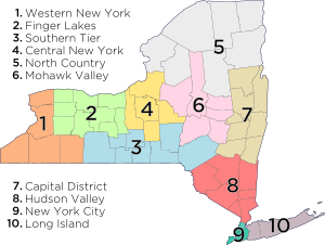
Due to its long history, the state of New York has several overlapping (and often conflicting) definitions of regions within the state. This is further exacerbated by the colloquial use of such regional labels. The New York State Department of Economic Development provides two distinct definitions of these regions. It divides the state into ten economic regions,[55] which approximately correspond to terminology used by local residents:

  1. Western New York
  2. Finger Lakes
  3. Southern Tier
  4. Central New York
  5. North Country
  6. Mohawk Valley
  7. Capital District
  8. Hudson Valley
  9. New York City
  10. Long Island
Tourism regions of New York

The Department of Economic Development also groups the counties into eleven regions for tourism purposes:[56]

  1. Chautauqua–Allegheny
  2. Niagara Frontier
  3. Finger Lakes
  4. Thousand Islands
  5. Central Region (formerly Central-Leatherstocking)
  6. Adirondack Mountains
  7. Capital District
  8. Catskill Mountains
  9. Hudson Valley
  10. New York City
  11. Long Island

Administrative divisions

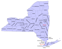
Map of the counties in New York

New York is divided into 62 counties. Aside from the five counties of New York City, each of these counties is subdivided into towns and cities. Towns can contain incorporated villages or unincorporated hamlets. New York City is divided into five boroughs, each coterminous with a county.

Most populous counties

These are the ten counties with the largest populations as of 2010:[57]

  1. Kings County (Brooklyn): 2,504,700
  2. Queens County (Queens): 2,230,722
  3. New York County (Manhattan): 1,585,873
  4. Suffolk County: 1,493,350
  5. Bronx County (the Bronx): 1,385,108
  6. Nassau County: 1,339,532
  7. Westchester County: 949,113
  8. Erie County: 919,040
  9. Monroe County: 744,344
  10. Richmond County (Staten Island): 468,730

Cities and metropolitan areas

There are 62 cities in New York. The largest city in the state and the most populous city in the United States is New York City, which comprises five counties (boroughs): Bronx, New York (Manhattan), Queens, Kings (Brooklyn), and Richmond (Staten Island). New York City is home to more than two-fifths of the state's population. Albany, the sixth-largest city, is the state capital. The smallest city is Sherrill, New York, in Oneida County. Hempstead is the town with the largest population. If it were a city, it would be the second largest in the state, with over 700,000 residents.


The following are the ten largest metropolitan areas in the state:[58]

  1. New York City (19,831,858 in NY/NJ/PA,[59] 12,368,525 in NY)
  2. Buffalo-Niagara Falls (1,135,509)
  3. Rochester (1,054,323)
  4. Albany and the Capital District (870,716)
  5. Poughkeepsie and the Hudson Valley (670,301)
  6. Syracuse (662,577)
  7. Utica-Rome (299,397)
  8. Binghamton (251,725)
  9. Kingston (182,493)
  10. Glens Falls (128,923)

Downstate New York (New York City, Long Island, and the southern portion of the Hudson Valley) can be considered to form the central core of the Northeast megalopolis, an urbanized region stretching from New Hampshire to Virginia.

The major cities of the state developed along the key transportation and trade routes of the early 19th century, including the Erie Canal and railroads paralleling it. Today, the New York Thruway acts as a modern counterpart to commercial water routes.[citation needed]

Demographics

Historical population
CensusPop. %±
1790 340,120  
—
1800 589,051   73.2%
1810 959,049   62.8%
1820 1,372,812   43.1%
1830 1,918,608   39.8%
1840 2,428,921   26.6%
1850 3,097,394   27.5%
1860 3,880,735   25.3%
1870 4,382,759   12.9%
1880 5,082,871   16.0%
1890 6,003,174   18.1%
1900 7,268,894   21.1%
1910 9,113,614   25.4%
1920 10,385,227   14.0%
1930 12,588,066   21.2%
1940 13,479,142   7.1%
1950 14,830,192   10.0%
1960 16,782,304   13.2%
1970 18,236,967   8.7%
1980 17,558,072   −3.7%
1990 17,990,455   2.5%
2000 18,976,457   5.5%
2010 19,378,102   2.1%
Est. 2013 19,651,127   1.4%
Sources: 1910–2010 1790–1900[60]
2013 Estimate[61]

Population

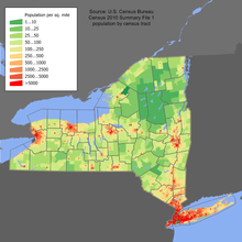
New York population distribution map

The distribution of change in population growth is uneven in New York State; the New York City metropolitan area is growing considerably, along with Saratoga County, while most of Western New York is nearly stagnant. According to immigration statistics, the state is a leading recipient of migrants from around the globe. Between 2000 and 2005, immigration failed to surpass emigration, a trend that has been reversing since 2006. New York State lost two house seats in the 2011 congressional reapportionment, secondary to relatively slow growth when compared to the rest of the United States. In 2000 and 2005, more people moved from New York to Florida than from any one state to another.[62] However, New York State has the second largest international immigrant population in the country among the American states, at 4.2 million as of 2008; most reside in and around New York City, due to its size, high profile, vibrant economy, and cosmopolitan culture.

The United States Census Bureau estimates that the population of New York was 19,651,127 on July 1, 2013, a 1.4% increase since the 2010 United States Census.[4] In spite of the open land in the state, New York's population is very urban, with 92% of residents living in an urban area,[63] predominantly in the New York City metropolitan area.

Two-thirds of New York State's population resides within the New York City Metropolitan Area. New York City is the most populous city in the United States,[64][65] with an estimated record high of 8,336,697 residents as of 2012,[8] incorporating more immigration into the city than emigration since the 2010 United States Census.[66] More people live in New York City than in the next two most populous U.S. cities (Los Angeles[67] and Chicago[68]) combined, which, according to the United States Census Bureau, is estimated to total 6,572,655. Long Island alone accounted for a Census-estimated 7,740,208 residents in 2013, representing 39.4% of New York State's population.[21][22][23][24]

Racial and ancestral makeup

The Manhattan Chinatown (紐約華埠). The Chinese population constitutes the fastest-growing nationality in New York State.[69][70][71][72]

According to the U.S. Census Bureau, the 2010 racial makeup of New York State was as follows:[73]

New York Racial Breakdown of Population
[hide]Racial composition1950[74]1970[74]1990[74]2000[75]2010[76]
White 93.5% 86.8% 74.4% 67.9% 65.8%
Black 6.2% 11.9% 15.9% 15.9% 15.9%
Asian 0.2% 0.7% 3.9% 5.5% 7.3%
Native 0.1% 0.2% 0.3% 0.4% 0.6%
Native Hawaiian and
other Pacific Islander
– – – 0.1% 0.1%
Other race – 0.4% 5.5% 7.1% 7.4%
Two or more races – – – 3.1% 3.0%

In 2004, the major ancestry groups in New York State were Hispanic and Latino Americans (17.6%), African American (15.8%), Italian (14.4%), Irish (12.9%), German (11.1%) and English (6%).[77] According to a 2010 estimate, 21.7% of the population is foreign-born.[73]

New York population ethnicity map

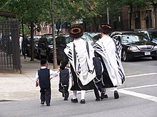
The state's most populous racial group, non-Hispanic white, has declined from 94.6% in 1940 to 58.3% in 2010.[73][78] As of 2011, 55.6% of New York's population younger than age 1 were minorities.[79] New York's robustly increasing Jewish population was the highest among states both by absolute number and by percentage in 2012,[80] driven by the rapidly growing Orthodox Jewish population,[81] particularly in Brooklyn and the Hudson Valley.

New York is home to the largest African-American population and the second largest Asian-American population in the United States, although New York's Black population declined between 2000 and 2010.[82] In addition it is home to the largest Puerto Rican, Dominican, and Jamaican American populations in the continental United States. The New York City neighborhood of Harlem has historically been a major cultural capital for African-Americans of sub-Saharan descent, and Bedford-Stuyvesant in Brooklyn is the largest such population in the United States.

Queens, also in New York City, is home to the state's largest Asian-American population and is the most ethnically diverse county in the United States, as well as being the most ethnically diverse urban area in the world.[83][84] The Chinese population constitutes the fastest-growing nationality in New York State; multiple satellites of the original Manhattan Chinatown (紐約華埠), in Brooklyn (布鲁克林華埠), and around Flushing, Queens (法拉盛華埠), are thriving as traditionally urban enclaves, while also expanding rapidly eastward into suburban Nassau County (拿騷縣),[85] on Long Island (長島),[86] as New York State has become the top destination for new Chinese immigrants, and large-scale Chinese immigration continues into New York.[69][70][71][72][87] Long Island, including Queens and Nassau County, is also home to several Little Indias and a large Koreatown (롱 아일랜드 코리아타운), with large and growing attendant populations of Indian Americans and Korean Americans, respectively; while Brooklyn is receiving large numbers of both West Indian as well as Asian Indian immigrants. Queens is also home to the largest Andean (Colombian, Ecuadorian, Peruvian, and Bolivian) populations in the United States.

In the 2000 Census, Italian Americans, with the largest number among the American states, made up the largest ancestral group in Staten Island and Long Island, followed by Irish Americans. Albany and the Mohawk Valley also have populations with many of Irish-American and Italian-American descent. In Buffalo and western New York, German Americans comprise the largest ancestry; while in the North Country of New York, French Canadians represent the leading ethnic descent, given its proximity to Quebec. Americans of English ancestry are present throughout all of upstate New York.

6.5% of New York's population were under 5 years of age, 24.7% under 18, and 12.9% were 65 or older. Females made up 51.8% of the population.

Languages

In 2010, the most common American English dialects spoken in New York, besides General American English, were the New York City area dialect (including New York Latino English and North Jersey English), Hudson Valley English (including the Western New England accent around Albany), and Inland Northern American English in Buffalo and western New York State. As many as 800 languages are spoken in New York City,[88][89] making it the most linguistically diverse city in the world.[90]

As of 2010, 70.72% (12,788,233) of New York residents aged five and older reported speaking only English at home, while 14.44% (2,611,903) spoke Spanish, 2.61% (472,955) Chinese (which includes Cantonese and Mandarin), 1.20% (216,468) Russian, 1.18% (213,785) Italian, 0.79% (142,169) French Creole, 0.75% (135,789) French, 0.67% (121,917) Yiddish, 0.63% (114,574) Korean, and Polish was spoken by 0.53% (95,413) of the population over the age of five. In total, 29.28% (5,295,016) of New York's population aged five and older reported speaking a language other than English.[2]

Most common non-English languages spoken in New York
LanguagePercentage of population
(as of 2010)[2]
Spanish 14.44%
Chinese (including Cantonese and Mandarin) 2.61%
Russian 1.20%
Italian 1.18%
French Creole 0.79%
French 0.75%
Yiddish 0.67%
Korean 0.63%
Polish 0.53%
Bengali 0.43%

Religion

Brooklyn's growing Jewish community is the largest in the United States, with approximately 600,000 individuals.[91]

In 2000, Catholics comprised more than 40% of the population in New York; Protestants were 30% of the population, Jews 8.4%, Muslims 3.5%, Buddhists 1%, and 13% claimed no religious affiliation (irreligious, agnostics, and atheists).

In 2010, the Association of Religion Data Archives (ARDA) reported that the largest denominations were the Catholic Church with 6,286,916; Orthodox Judaism with 588,500; Islam with 392,953; and the United Methodist Church with 328,315 adherents.[92]

LGBT

Roughly 3.8 per cent of the state's adult population self-identifies as lesbian, gay, bisexual, or transgender. This constitutes a total LGBT adult population of 570,388 individuals.[93] In 2010, the number of same-sex couple households stood at roughly 48,932.[94] New York was the fifth state to license same-sex marriages, after New Hampshire. Michael Bloomberg, the Mayor of New York City, stated that "same sex-marriages in New York City have generated an estimated $259 million in economic impact and $16 million in City revenues" in the first year after the enactment of the Marriage Equality Act".[95]Same-sex marriages in New York were legalized on June 24, 2011 and were authorized to take place beginning 30 days thereafter.[96]

Economy
Main article: Economy of New York
2001 NY Proof.png
The New York Stock Exchange, the world's largest stock exchange by total market capitalization of its listed companies.[97]
Presidential $1 Reverse.png
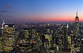
Midtown Manhattan in New York City, the largest central business district in the United States

New York's gross state product in 2010 was $1.16 trillion, ranking third in size behind the larger states of California and Texas.[98] If New York were an independent nation, it would rank as the 16th largest economy in the world behind Turkey. Its 2007 per capita personal income was $46,364, placing it sixth in the nation behind Maryland, and eighth in the world behind Ireland. New York's agricultural outputs are dairy products, cattle and other livestock, vegetables, nursery stock, and apples. Its industrial outputs are printing and publishing, scientific instruments, electric equipment, machinery, chemical products, and tourism. Sand, gravel, asphalt, and cement production are also significant industries in the state.

New York City's financial district, anchored by Wall Street in Lower Manhattan, has been called the world's leading financial center[99][100][101] and is home to the New York Stock Exchange, the world's largest stock exchange by total market capitalization of its listed companies.[102] Wall Street, a metonym for New York City's securities industry, provided approximately $26.7 billion in bonuses, and 16 percent of revenue, or $10.3 billion, for New York State in 2013.[103][104] Many of the world's largest media conglomerates are also based in the city.

Silicon Alley, centered in New York City, has evolved into a metonym for the sphere encompassing the New York metropolitan region's high technology and entrepreneurship ecosystem; in the first half of 2014, New York State generated nearly US$1.8 billion in venture capital investment.[105] High tech industries including digital media, biotechnology, software development, game design, and other fields within information technology are growing, bolstered by New York City's position at the terminus of several transatlantic fiber optic trunk lines,[106] its intellectual capital, as well as its growing outdoor wireless connectivity.[107]

Creative industries such as new media, advertising, fashion, design and architecture account for a growing share of employment, with New York City possessing a strong competitive advantage in these industries.[108]

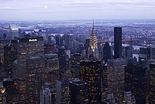
Manhattan contained approximately 520 million square feet (48.1 million m²) of office space in 2013,[109] making it the largest office market in the United States,[110] while Midtown Manhattan is the largest central business district in the nation.[111]

Lower Manhattan is the third largest central business district in the United States and is home to the New York Stock Exchange, on Wall Street, and the NASDAQ, at 165 Broadway, representing the world's largest and second largest stock exchanges, respectively, when measured both by overall average daily trading volume and by total market capitalization of their listed companies in 2013.[97] Investment banking fees on Wall Street totaled approximately US$40 billion in 2012,[112] while in 2013, senior New York City bank officers who manage risk and compliance functions earned as much as US$324,000 annually.[113]

New York exports a wide variety of goods such as foodstuffs, commodities, minerals, computers and electronics, cut diamonds, and automobile parts. In 2007, the state exported a total of $71.1 billion worth of goods, with the five largest foreign export markets being Canada ($15 billion), United Kingdom ($6 billion), Switzerland ($5.9 billion), Israel ($4.9 billion), and Hong Kong ($3.4 billion). New York's largest imports are oil, gold, aluminum, natural gas, electricity, rough diamonds, and lumber.

Albany, Saratoga County, and the Hudson Valley are major centers of nanotechnology and integrated microchip circuit manufacturing, while the Rochester area is important in the field of photographic processing and imaging. The state also has a large manufacturing sector that includes printing and the production of garments, furs, railroad equipment and bus line vehicles; many of these industries are concentrated in Upstate regions.

New York is a major agricultural producer, ranking among the top five states for agricultural products such as dairy, apples, cherries, cabbage, potatoes, onions, and maple syrup. The state is the largest producer of cabbage in the U.S. The state has about a quarter of its land in farms and produced US$3.4 billion in agricultural products in 2001. The south shore of Lake Ontario provides the right mix of soils and microclimate for many apple, cherry, plum, pear and peach orchards. Apples are also grown in the Hudson Valley and near Lake Champlain.

New York is the nation's third-largest grape-producing state, and second-largest wine producer by volume, behind California. The south shore of Lake Erie and the southern Finger Lakes hillsides have many vineyards. In addition, the North Fork of Long Island developed vineyards, production and visitors' facilities in the last three decades of the 20th century. In 2004, New York's wine and grape industry brought US$6 billion into the state economy.

The state has 30,000 acres (120 km2) of vineyards, 212 wineries, and produced 200 million bottles of wine in 2004. A moderately sized saltwater commercial fishery is located along the Atlantic side of Long Island. The principal catches by value are clams, lobsters, squid, and flounder.

Transportation

New York State Thruway
The New York City Subway serves more than 5 million rides on a given weekday.

New York has one of the most extensive and one of the oldest transportation infrastructures in the country. Engineering difficulties because of the terrain of the state and the unique issues of the city brought on by urban crowding have had to be overcome perennially. Population expansion of the state generally followed the path of the early waterways, first the Hudson River and then the Erie Canal. Today, railroad lines and the New York State Thruway follow the same general route. The New York State Department of Transportation is often criticized for how they maintain the roads of the state in certain areas and for the fact that the tolls collected along the roadway have long passed their original purpose. Until 2006, tolls were collected on the Thruway within The City of Buffalo. They were dropped late in 2006 during the campaign for Governor (both candidates called for their removal).

In addition to New York City's famous mass transit subway, four suburban commuter railroad systems enter and leave the city: the Long Island Rail Road, Metro-North Railroad, Port Authority Trans-Hudson, and five of New Jersey Transit's rail lines. Many other cities have urban and regional public transportation. In Buffalo, the Niagara Frontier Transportation Authority runs the Buffalo Metro Rail light-rail system; in Rochester, the Rochester Subway operated from 1927 until 1956 but has fallen into disuse.

License plate introduced on April 1, 2010 for vehicles registered in New York State.
Former License plate design introduced in 2001

The New York State Department of Motor Vehicles (NYSDMV or DMV) is the governmental agency responsible for registering and inspecting automobiles and other motor vehicles as well as licensing drivers in the State of New York. As of 2008, the NYSDMV has 11,284,546 drivers licenses on file[114] and 10,697,644 vehicle registrations in force.[115] All gasoline powered vehicles registered in New York State must get an emissions inspection every 12 months. Diesel powered vehicles with a Gross Weight Rating over 8 500 lb that are registered in the NY Metropolitan Area must get an annual emissions inspection. All vehicles registered in NYS must get an annual safety inspection.

Portions of the transportation system are intermodal, allowing travelers to easily switch from one mode of transportation to another. One of the most notable examples is AirTrain JFK which allows rail passengers to travel directly to terminals at John F. Kennedy International Airport.

In May 2009, the New York City Department of Transportation under the control of Transportation Commissioner Janette Sadik-Khan banned cars from Times Square in a move designed to improve traffic flow and reduce pollution and pedestrian accidents.[116] On February 11, 2010, Mayor Michael Bloomberg announced that the pedestrian plazas would remain permanent.[117]

Law, government and politics

Government

The Government of New York is the governmental structure of the State of New York as established by the New York State Constitution. It is composed of three branches: executive, legislative and judicial.

The New York State Legislature is bicameral and consists of the New York State Senate and the New York State Assembly. The Assembly consists of 150 members; the Senate varies in its number of members, but currently has 63. The Legislature is empowered to make laws, subject to the Governor's power to veto a bill. However, the veto may be overridden by the Legislature if there is a two-thirds majority in favor of overriding in each House. The permanent laws of a general nature are codified in the Consolidated Laws of New York.

The Governor is the State's chief executive and is assisted by the Lieutenant Governor. Both are elected on the same ticket. Additional elected officers include the Secretary of State, the Attorney General, and the Comptroller. There are also several state government departments.

The highest court of appeal in the New York State Unified Court System is the Court of Appeals whereas the primary felony trial courts are the Supreme Court and the county courts (outside of New York City). The Supreme Court also acts as the intermediate appellate court for many cases, and the local courts handle a variety of other matters including small claims, traffic ticket cases and local zoning matters, and are the starting point for all criminal cases. The New York City Courts make up the largest local court system.

The state is divided into counties, cities, towns, and villages, which are all municipal corporations with their own government, as well as various corporate entities that serve single purposes that are also local governments, such as school, fire districts, and New York state public-benefit corporations, frequently known as authorities or development corporations. It also has 10 Indian reservations. Each municipal corporation is granted varying home rule powers as provided by the New York Constitution.

Federal representation

The State of New York sends 27 members to the House of Representatives[118] in addition to its two United States Senators. As of the 2000 census and the redistricting for the 2002 elections, the state had 29 members in the House, but the representation was reduced to 27 in 2013 due to the state's slower overall population growth relative to the overall national population growth.[119] From 2016 New York will have 29 electoral votes in national presidential elections (a drop from its peak of 47 votes from 1933 to 1953).

New York is represented by Chuck Schumer and Kirsten Gillibrand in the United States Senate and has the nation's third equal highest number of congressional districts, equal with Florida and behind California's 53 and Texas's 36.

Politics

New York State Presidential Election Results
YearDemocraticRepublican
  2012 63.35% 4,485,877 35.17% 2,490,496
  2008 62.88% 4,804,945 36.03% 2,752,771
  2004 58.37% 4,314,280 40.08% 2,962,567
  2000 60.21% 4,107,907 35.23% 2,403,374
  1996 59.47% 3,756,177 30.61% 1,933,492
  1992 49.73% 3,444,450 33.88% 2,346,649
  1988 51.62% 3,347,882 47.52% 3,081,871
  1984 45.83% 3,119,609 53.84% 3,664,763
  1980 43.99% 2,728,372 46.66% 2,893,831
  1976 51.95% 3,389,558 47.52% 3,100,791
  1972 41.21% 2,951,084 58.54% 4,192,778
  1968 49.76% 3,378,470 44.30% 3,007,932
  1964 68.56% 4,913,156 31.31% 2,243,559
  1960 52.53% 3,830,085 47.27% 3,446,419

In the last few decades, New York State has generally supported candidates belonging to the Democratic Party in national elections. Democratic presidential candidate Barack Obama won New York State by 25 percentage points in 2008, a bigger margin than John Kerry in 2004. New York City is a major Democratic stronghold with liberal politics. Many of the state's other urban areas, such as Albany, Buffalo, Rochester, and Syracuse are also Democratic. Rural upstate New York, however, is generally more conservative than the cities and tends to favor Republicans. Heavily populated suburban areas downstate, such as Westchester County and Long Island, have swung between the major parties over the past 25 years, but more often than not support Democrats.

New York City is the most important source of political fundraising in the United States for both major parties. Four of the top five zip codes in the nation for political contributions are in Manhattan. The top zip code, 10021 on the Upper East Side, generated the most money for the 2000 presidential campaigns of both George W. Bush and Al Gore.[120]

The state has a strong imbalance of payments with the federal government. New York State receives 82 cents in services for every $1 it sends in taxes to the federal government in Washington.[121] The state ranks near the bottom, in 42nd place, in federal spending per tax dollar.[122]

Education

Main article: Education in New York

The University of the State of New York oversees all public primary, middle-level, and secondary education in the state, while the New York City Department of Education manages the public school system in New York City. In 1894, reflecting general racial discrimination, the state passed a law that allowed communities to set up schools for children of African-American descent. In 1900, the state passed another law requiring integrated schools.[123]

At the post-secondary level, the statewide public university system is the State University of New York commonly referred to as SUNY. New York City also has its own City University of New York which is additionally funded by the city. The SUNY system consists of 64 community colleges, technical colleges, undergraduate colleges, and doctoral-granting institutions including several universities. The four SUNY university centers, offering a wide array of academic programs, are the University at Albany, Binghamton University, the University at Buffalo, and Stony Brook University.

In addition there are many notable private universities such as New York Institute of Technology, New York University, and the oldest Catholic institution in the Northeast, Fordham University. New York is home to both Columbia University in New York City and Cornell University in Ithaca, making it the only state to contain more than one Ivy League school. Syracuse University is located in the city of Syracuse in Central New York. West Point, the service academy of the U.S. Army, is located just south of Newburgh, on the banks of the Hudson River.

During the 2007–2008 school year, New York spent more per pupil on public education than any other state.[124]

Sports

Main article: Sports in New York

New York hosted the 1932 and 1980 Winter Olympics at Lake Placid. The 1980 Games are known for the USA–USSR hockey game dubbed the "Miracle on Ice" in which a group of American college students and amateurs defeated the heavily favored Soviet national ice hockey team 4–3 and went on to win the gold medal against Finland. Along with St. Moritz, Switzerland and Innsbruck, Austria, Lake Placid is one of the three cities to have hosted the Winter Olympic Games twice. New York City bid to host the 2012 Summer Olympics but lost to London.

New York is the home of one National Football League team, the Buffalo Bills (based in the suburb of Orchard Park). Although the New York Giants and New York Jets represent the New York metropolitan area and were previously located in New York City, they play in MetLife Stadium, located in East Rutherford, New Jersey. The Meadowlands stadium hosted Super Bowl XLVIII in 2014, in which New York and New Jersey will share hosting duties. There was much controversy over several proposals for a new New York Jets football stadium. The owners of the New York Jets were willing to split the $1.5 billion cost of building a new football stadium over Manhattan's West Side rail yards, but the proposal never came to fruition.

New York also has two Major League Baseball teams, the New York Yankees (based in the Bronx) and the New York Mets (based in Queens). New York is home to three National Hockey League franchises: the New York Rangers in Manhattan, the New York Islanders on Long Island and the Buffalo Sabres in Buffalo. New York has two National Basketball Association teams, the New York Knicks in Manhattan, and the Brooklyn Nets in Brooklyn. There are a variety of minor league teams that can be found throughout the State of New York, such as the Long Island Ducks. New York will be the home of a Major League Soccer franchise, New York City FC, starting in 2015. Although the New York Red Bulls represent the New York metropolitan area, they play in Red Bull Arena in Harrison, New Jersey.

New York State major league professional sports teams
ClubSportLeague
Buffalo Bills Football National Football League
Brooklyn Nets Basketball National Basketball Association
New York Knicks Basketball National Basketball Association
New York City FC Soccer Major League Soccer
Buffalo Sabres Ice hockey National Hockey League
New York Islanders Ice Hockey National Hockey League
New York Rangers Ice Hockey National Hockey League
New York Mets Baseball Major League Baseball
New York Yankees Baseball Major League Baseball

See also

References

  1. "New York State Motto". New York State Library. January 29, 2001. Archived from the original on June 8, 2007. Retrieved November 16, 2007.
  2. "New York". Modern Language Association. Retrieved August 6, 2013.
  3. "Land and Water Area of States (2000)". Infoplease.com. Retrieved April 11, 2008. Note: This area is based on U.S. Census Bureau figures. Other sources such as The World Almanac and the Rand McNally World Atlas use an area of 49,576 square miles (128,400 km2), which would rank the state 30th.
  4. "Table 1. Annual Estimates of the Population for the United States, Regions, States, and Puerto Rico: April 1, 2010 to July 1, 2013" (CSV). 2013 Population Estimates. United States Census Bureau, Population Division. December 30, 2013. Retrieved January 6, 2014.
  5. "Marcy". NGS data sheet. U.S. National Geodetic Survey. Retrieved October 20, 2011.
  6. "Elevations and Distances in the United States". United States Geological Survey. 2001. Retrieved October 24, 2011.
  7. Elevation adjusted to North American Vertical Datum of 1988.
  8. Michael Howard Saul (March 27, 2014). "New York City Population Hits Record High". The Wall Street Journal. Retrieved August 2, 2014.
  9. "Yearbook of Immigration Statistics: 2013 Lawful Permanent Residents Supplemental Table 2". U.S. Department of Homeland Security. Retrieved August 2, 2014.
  10. "Yearbook of Immigration Statistics: 2012 Supplemental Table 2". U.S. Department of Homeland Security. Retrieved August 2, 2014.
  11. "Yearbook of Immigration Statistics: 2011 Supplemental Table 2". U.S. Department of Homeland Security. Retrieved August 2, 2014.
  12. "GLOBAL POWER CITY INDEX 2009". The Mori Memorial Foundation. Retrieved August 2, 2014.
  13. "United Nations Visitors Centre". United Nations. 2011. Retrieved August 2, 2014.
  14. "Office of the Mayor Commission for the United Nations, Consular Corps and Protocol". The City of New York. 2012. Retrieved August 2, 2014.
  15. "Consulate General of Iceland New York Culture". Consulate General of Iceland New York. Retrieved August 2, 2014.
  16. "Consulate of Latvia in New York". Consulate of Latvia. Retrieved February 17, 2013.
  17. "Introduction to Chapter 14: New York City (NYC) Culture". The Weissman Center for International Business Baruch College/CUNY 2011. Retrieved August 2, 2014.
  18. "New York, Culture Capital of the World, 1940–1965 / edited by Leonard Wallock ; essays by Dore Ashton ... [et al.]". NATIONAL LIBRARY OF AUSTRALIA. Retrieved August 2, 2014.
  19. "Top 8 Cities by GDP: China vs. The U.S.". Business Insider, Inc. July 31, 2011. Retrieved August 2, 2014.
  20. "Kings County, New York QuickFacts". U.S. Census Bureau. Retrieved August 2, 2014.
  21. "Queens County, New York QuickFacts". U.S. Census Bureau. Retrieved August 2, 2014.
  22. "Nassau County, New York QuickFacts". U.S. Census Bureau. Retrieved August 2, 2014.
  23. "Suffolk County, New York QuickFacts". U.S. Census Bureau. Retrieved August 2, 2014.
  24. Nevius, Michelle and James, "New York's many 9/11 anniversaries: the Staten Island Peace Conference", Inside the Apple: A Streetwise History of New York City, September 8, 2008. Retrieved September 24, 2012.
  25. Scheltema, Gajus and Westerhuijs, Heleen (eds.),Exploring Historic Dutch New York. Museum of the City of New York/Dover Publications, New York (2011). ISBN 978-0-486-48637-6
  26. "Declaration of Independence". history.com. Archived from the original on April 9, 2008. Retrieved April 10, 2008.
  27. Alan Taylor (2006). The Divided Ground: Indians, Settlers, and the Northern Borderland of the American Revolution. Knopf. ISBN 978-0-679-45471-7.
  28. "Sullivan/Clinton Interactive Map Set". Retrieved August 30, 2010.
  29. Chen, David W. Battle Over Iroquois Land Claims Escalates The New York Times. May 16, 2000. . Retrieved April 11, 2008.
  30. "Happy Evacuation Day". New York City Department of Parks and Recreation. Retrieved April 12, 2008.
  31. "New York's Ratification". The U.S. Constitution Online. Retrieved April 10, 2008.
  32. "The Erie Canal: A Brief History". New York State Canals. Retrieved April 10, 2008.
  33. Phisterer, Frederick, New York in the War of the Rebellion, 1861 To 1865, Albany: Weed, Parsons and Co., 1890, p. 88.
  34. Edelman, Susan (January 6, 2008). "Charting post-9/11 deaths". Retrieved January 22, 2012.
  35. Katia Hetter (November 12, 2013). "It's official: One World Trade Center to be tallest U.S. skyscraper". CNN. Retrieved November 12, 2013.
  36. Mary Johnson (October 29, 2012). "VIDEO: Dramatic Explosion at East Village Con Ed Plant". Copyright © 2009–2012, DNAinfo.com. All Rights Reserved. Retrieved December 2, 2012.
  37. Robert S. Eshelman (November 15, 2012). "ADAPTATION: Political support for a sea wall in New York Harbor begins to form". © 1996–2012 E&E Publishing, LLC. Retrieved December 2, 2012.
  38. "Castle Garden as An Immigrant Depot:1855–1890" (PDF). National Park Service. Retrieved September 9, 2013.
  39. "Castle Clinton". National Park Service. August 22, 2013. Retrieved September 9, 2013.
  40. Vincent J. Cannato: American Passage: The History of Ellis Island. p.50: Harper Collins (2009) ISBN 0060742739
  41. Linda Greenhouse (May 27, 1998). "The Ellis Island Verdict: The Ruling". The New York Times. Retrieved September 5, 2013.
  42. "Statue Of Liberty National Monument". Nps.gov. Retrieved September 9, 2013.
  43. "Elevations and Distances in the United States". U.S Geological Survey. April 29, 2005. Retrieved November 6, 2006.
  44. About the Adirondack Park, Adirondack Park Agency. Retrieved July 1, 2009.
  45. Eisenstadt, Peter, ed. (2005). The Encyclopedia of New York State. Syracuse University Press. p. 1619. ISBN 978-0-8156-0808-0.
  46. Eisenstadt, Peter, ed. (2005). The Encyclopedia of New York State. Syracuse University Press. p. 1437. ISBN 978-0-8156-0808-0.
  47. Eisenstadt, Peter, ed. (2005). The Encyclopedia of New York State. Syracuse University Press. ISBN 978-0-8156-0808-0.
  48. "Climate of New York". New York State Climate Office – Cornell University. Retrieved April 10, 2008.
  49. The New York Post (June 3, 2007). "A Breath of Fresh New York Air". Retrieved June 6, 2007.[dead link]
  50. "Typical High and Low Temperatures For Various New York Cities". US Travel Weather. Retrieved March 24, 2010.
  51. Largest Park Area in the Contiguous US Remains Open to Visitors, Thursday, October 3, 2013. Regional Office of Sustainable Tourism / Lake Placid CVB. Retrieved 26 July 2014.
  52. "Catskill Park History". catskillpark.org. Archived from the original on July 5, 2008. Retrieved April 11, 2008.
  53. "Statue of Liberty". World Heritage. UNESCO. Retrieved November 24, 2013.
  54. "Age/sex/race in New York State: Based on Census 2010". Retrieved May 15, 2012.
  55. "Map of eleven regions". Visitnewyorkstate.net. Retrieved October 2, 2010.
  56. "State & County QuickFacts New York". United States Census Bureau. Retrieved November 14, 2013.
  57. "2010 Census National Summary File of Redistricting Data – Population and Housing Occupancy Status: 2010 – United States – Metropolitan Statistical Area; and for Puerto Rico". 2010 United States Census. United States Census Bureau, Population Division. April 14, 2011. Retrieved March 14, 2012.
  58. "Geographic area,"April 1, 2010",,Population estimates (as of July 1),, ,,,Census,Estimates base,2010,2011,2012". U.S. Census Bureau. Retrieved November 12, 2013.
  59. "New York: 2000 (Population and Housing Unit Counts)" (PDF). 2000 United States Census. United States Census Bureau. 2000. Retrieved September 18, 2010. (page 1 of the document, page 31 of the file)
  60. "Table 1. Annual Estimates of the Population for the United States, Regions, States, and Puerto Rico: April 1, 2010 to July 1, 2013". Retrieved January 1, 2014.
  61. "Domestic Migration Flows for States from the 2005 ACS" (Microsoft Word). Archived from the original on October 25, 2007. Retrieved October 19, 2007.
  62. Timothy S. Parker (September 10, 2010). "New York Fact Sheet: NY agriculture income population food education employment farms top commodities exports counties financial indicators poverty organic farming farm income America USDA". Ers.usda.gov. Retrieved October 2, 2010.
  63. "Annual Estimates of the Resident Population for Incorporated Places Over 50,000, Ranked by July 1, 2011 Population: April 1, 2010 to July 1, 2011". U.S. Census Bureau. Retrieved November 12, 2013.
  64. Blake Ellis (March 25, 2011). "America's 5 biggest cities". CNN. Retrieved November 12, 2013.
  65. Roberts, Sam (March 14, 2013). "Fewer People Are Abandoning the Bronx, Census Data Show". New York Times.
  66. "State & County QuickFacts Los Angeles (city), California". U.S. Census Bureau. Retrieved November 12, 2013.
  67. "State & County QuickFacts Chicago (city), Illinois". U.S. Census Bureau. Retrieved November 12, 2013.
  68. "Yearbook of Immigration Statistics: 2013 Lawful Permanent Residents Supplemental Table 1". U.S. Department of Homeland Security. Retrieved June 16, 2014.
  69. "Yearbook of Immigration Statistics: 2012 Supplemental Table 1". U.S. Department of Homeland Security. Retrieved November 10, 2013.
  70. "Yearbook of Immigration Statistics: 2011 Supplemental Table 1". U.S. Department of Homeland Security. Retrieved November 10, 2013.
  71. "Yearbook of Immigration Statistics: 2010 Supplemental Table 1". U.S. Department of Homeland Security. Retrieved November 10, 2013.
  72. "New York QuickFacts". U.S. Census Bureau. January 17, 2012. Retrieved April 18, 2012.
  73. Historical Census Statistics on Population Totals By Race, 1790 to 1990, and By Hispanic Origin, 1970 to 1990, For The United States, Regions, Divisions, and States
  74. Population of New York: Census 2010 and 2000 Interactive Map, Demographics, Statistics, Quick Facts
  75. 2010 Census Data
  76. Awesome America: New York. Retrieved August 18, 2007.
  77. "New York – Race and Hispanic Origin: 1790 to 1990". U.S. Census Bureau. Retrieved April 18, 2012.
  78. "Americans under age 1 now mostly minorities, but not in Ohio: Statistical Snapshot". The Plain Dealer. June 3, 2012.
  79. "Jewish Population in the United States, by State". American-Israeli Cooperative Enterprise. Retrieved November 11, 2013.
  80. David Brooks (March 7, 2013). "The Orthodox Surge". The New York Times. Retrieved November 11, 2013.
  81. "State & County QuickFacts New York QuickLinks". United States Census Bureau. Retrieved November 11, 2013.
  82. Christine Kim, Demand Media. "Queens, New York, Sightseeing". USA TODAY. Retrieved July 19, 2014.
  83. Andrew Weber (April 30, 2013). "Queens". NewYork.com. Retrieved July 19, 2014.
  84. "State & County QuickFacts Nassau County, New York QuickLinks". United States Census Bureau. Retrieved November 14, 2013.
  85. Heng Shao (April 10, 2014). "Join The Great Gatsby: Chinese Real Estate Buyers Fan Out To Long Island's North Shore". Forbes. Retrieved August 2, 2014.
  86. John Marzulli (May 9, 2011). "Malaysian man smuggled illegal Chinese immigrants into Brooklyn using Queen Mary 2: authorities". The New York Daily News. Retrieved November 10, 2013.
  87. "Endangered Language Alliance". 2012. Retrieved November 11, 2013.
  88. "Linguistics- Say what?". The Economist. September 10, 2011. Retrieved November 11, 2013.
  89. Roberts, Sam (April 28, 2010). "Listening to (and Saving) the World's Languages". The New York Times. Retrieved November 11, 2013.
  90. Simone Weichselbaum (June 26, 2012). "Nearly one in four Brooklyn residents are Jews, new study finds". New York Daily News. Retrieved May 30, 2013.
  91. "The Association of Religion Data Archives | State Membership Report". www.thearda.com. Retrieved November 27, 2013.
  92. "LGBT Percentage Highest in D.C., Lowest in North Dakota". State of the States. Gallup Politics. February 15, 2013.
  93. Williams Inst. Census Snapshot http://williamsinstitute.law.ucla.edu/category/research/census-lbgt-demographics-studies/
  94. "NYC Same-Sex Marriages Generate $259 Million in Economic Impact". New York City Mayor Bloomberg, retrieved November 26, 2013
  95. Nicholas Confessore and Michael Barbaro (June 24, 2011). "New York Allows Same-Sex Marriage, Becoming Largest State to Pass Law". The New York Times. Retrieved November 11, 2013.
  96. "2013 WFE Market Highlights". World Federation of Exchanges. Retrieved July 20, 2014.
  97. "GDP by State". Greyhill Advisors. Retrieved September 8, 2011.
  98. "UBS may move US investment bank to NYC". e-Eighteen.com Ltd. June 10, 2011. Retrieved March 26, 2014.
  99. Richard Florida (May 8, 2012). "What Is the World's Most Economically Powerful City?". The Atlantic Monthly Group. Retrieved March 26, 2014.
  100. "Table 1 GFCI 15 Ranks and Ratings - Page 7". Qatar Financial Centre Authority and Z/Yen Group. March 2014. Retrieved March 26, 2014.
  101. "Market Highlights for First Half-year 2010". World Federation of Exchanges. Retrieved March 26, 2014.
  102. Freeman Klopott and Michael J. Moore (March 12, 2014). "Wall Street Bonuses Grew 15% in New York, DiNapoli Says". Bloomberg L.P. Retrieved March 14, 2014.
  103. Joseph Spector, Gannett (October 22, 2013). "N.Y. comptroller: Rest of 2013 could be rocky for Wall St". Rochester Democrat and Chronicle. Retrieved November 12, 2013.
  104. "Industry Stats By Date". National Venture Capital Association. Retrieved July 20, 2014.
  105. "Telecommunications and Economic Development in New York City: A Plan for Action" (PDF). New York City Economic Development Corporation. March 2005. Archived from the original on March 7, 2008. Retrieved July 19, 2006.
  106. Ivan Pereira (December 10, 2013). "City opens nation's largest continuous Wi-Fi zone in Harlem". amNewYork/Newsday. Retrieved February 11, 2014.
  107. Currid, Elizabeth (2006). "New York as a Global Creative Hub: A Competitive Analysis of Four Theories on World Cities". Economic Development Quarterly 20 (4): 330–350. doi:10.1177/0891242406292708.
  108. "What is an office condominium?". Rudder Property Group. Retrieved May 28, 2013.
  109. "Understanding The Manhattan Office Space Market". Officespaceseeker.com. Retrieved July 20, 2014.
  110. "Marketbeat United States CBD Office Report 2Q11". Cushman & Wakefield, Inc. Retrieved July 20, 2014.
  111. Ambereen Choudhury, Elisa Martinuzzi & Ben Moshinsky (November 26, 2012). "London Bankers Bracing for Leaner Bonuses Than New York". Bloomberg L.P. Retrieved July 20, 2014.
  112. Sanat Vallikappen (November 10, 2013). "Pay Raises for Bank Risk Officers in Asia Trump New York". Bloomberg L.P. Retrieved July 20, 2014.
  113. "NYS DMV – Statistics – NYS Driver Licenses on File – 2008". New York State Department of Motor Vehicles. Retrieved July 2, 2010.
  114. "NYS DMV – Statistics – Vehicle Registrations in Force – 2008". New York State Department of Motor Vehicles. Retrieved July 2, 2010.
  115. "New York celebrates new era as cars are banished from Times Square". London: MailOnline. May 26, 2009. Retrieved December 12, 2011.
  116.   (February 11, 2010). "Pedestrian Plaza To Remain Permanent Fixture Of Times Square". NY1.com. Retrieved December 12, 2011.
  117. "Directory of Representatives". House.gov. Retrieved March 15, 2014.
  118. Rey, Jay pubdate=Dec 22, 2010. "N.Y.'s slow growth will mean loss of two seats in House". The Buffalo News. Archived from the original on May 16, 2012. Retrieved December 22, 2010.
  119. Opensecrets.org (May 16, 2005). "2006 Election Overview: Top Zip codes". Retrieved July 19, 2006.
  120. New York City Finance Division (March 11, 2005). "A Fair Share State Budget: Does Albany Play Fair with NYC?". Retrieved July 19, 2006.
  121. "Federal Spending in Each State Per Dollar of Federal Taxes FY2005". Tax Foundation. Retrieved April 12, 2008.
  122. Martha A. Sandweiss, Passing Strange: A Gilded Age Tale of Love and Deception Across the Color Line, New York: Penguin Press, 2009, p. 213
  123. Thomas, G. Scott (June 28, 2010). "New York Leads Nation in Education Spending". The Business Review (American City Business Journals, Inc). Retrieved June 29, 2010.

Americas

Americas

From Wikipedia, the free encyclopedia
For other uses, see America (disambiguation).
The Americas
Americas (orthographic projection).svg
Area 42,549,000 km2 (16,428,000 mi2)
Population 953.7 million (July 2013 estimate) [1]
Demonym American,[2] New Worlder,[3] and Pan-American[4] are used (see usage)
Countries 35
Languages Spanish, English, Portuguese, French, Quechua, Haitian Creole, Guaraní, Aymara, Nahuatl, Dutch and many others
Time zones UTC-10 to UTC

The Americas, or America,[5][6][7] also known as the New World, are the combined continental landmasses of North America and South America,[8][9] in the Western Hemisphere.[10] Along with their associated islands, they cover 8.3% of the Earth's total surface area (28.4% of its land area). The topography is dominated by the American Cordillera, a long chain of mountains that run the length of the west coast. The flatter eastern side of the Americas is dominated by large river basins, such as the Amazon, Mississippi, and La Plata. Since the Americas extend 14,000 km (8,700 mi) from north to south, the climate and ecology vary widely, from the arctic tundra of Northern Canada, Greenland, and Alaska, to the tropical rain forests in Central America and South America.

Humans first settled the Americas from Asia between 40,000 BCE and 15,000 BCE. A second migration of Na-Dene speakers followed later from Asia. The subsequent migration of the Inuit into the neoarctic around 3500 BCE completed what is generally regarded as the settlement by the indigenous peoples of the Americas. The first known European settlement in the Americas was by the Norse explorer Leif Ericson.[11] However the colonization never became permanent and was later abandoned. The voyages of Christopher Columbus from 1492 to 1502 resulted in permanent contact with European (and subsequently, other Old World) powers, which led to the Columbian exchange. Diseases introduced from Europe and Africa devastated the Indigenous peoples, and the European powers colonised the Americas.[12] Mass emigration from Europe, including large numbers of indentured servants, and forced immigration of African slaves largely replaced the Indigenous Peoples. Beginning with the American Revolution in 1776 and Haitian Revolution in 1791, the European powers began to decolonise the Americas. Currently, almost all of the population of the Americas resides in independent countries; however, the legacy of the colonisation and settlement by Europeans is that the Americas share many common cultural traits, most notably Christianity and the use of Indo-European languages; primarily Spanish, English, and Portuguese. More than 900 million people live in the Americas, the most populous countries being the United States, Brazil, and Mexico, the most populous cities being São Paulo, Mexico City and New York City.

History

Settlement

For more details on theories of Paleo-Indian migration, see Models of migration to the New World.

The first inhabitants migrated into the Americas from Asia. Habitation sites are known in Alaska and the Yukon from at least 20 000 years ago, with suggested ages of up to 40,000 years.[14][15][16] Beyond that, the specifics of the Paleo-Indian migration to and throughout the Americas, including the dates and routes traveled, are subject to ongoing research and discussion.[17] Widespread habitation of the Americas occurred during the late glacial maximum, from 16,000 to 13,000 years ago.[16][18] The traditional theory has been that these early migrants moved into the Beringia land bridge between eastern Siberia and present-day Alaska around 40,000–17,000 years ago,[19] when sea levels were significantly lowered due to the Quaternary glaciation.[17][20] These people are believed to have followed herds of now-extinct pleistocene megafauna along ice-free corridors that stretched between the Laurentide and Cordilleran ice sheets.[21] Another route proposed is that, either on foot or using primitive boats, they migrated down the Pacific coast to South America.[22] Evidence of the latter would since have been covered by a sea level rise of hundreds of meters following the last ice age.[23] Both routes may have been taken, although the genetic evidences suggests a single founding population.[24] The micro-satellite diversity and distributions specific to South American Indigenous people indicates that certain populations have been isolated since the initial colonization of the region.[25]

A second migration occurred after the initial peopling of the Americas;[26] Na Dene speakers found predominantly in North American groups at varying genetic rates with the highest frequency found among the Athabaskans at 42% derive from this second wave;[27] Linguists and biologists have reached a similar conclusion based on analysis of Amerindian language groups and ABO blood group system distributions.[26][28][29][30] Then the people of the Arctic small tool tradition a broad cultural entity that developed along the Alaska Peninsula, around Bristol Bay, and on the eastern shores of the Bering Strait around 2,500 BCE (4,500 years ago) moved into North America.[31] The Arctic small tool tradition, a Paleo-Eskimo culture branched off into two cultural variants, including the Pre-Dorset, and the Independence traditions of Greenland.[32] The decedents of the Pre-Dorset cultural group, the Dorset culture was displaced by the final migrants from the Bering sea coast line the ancestors of modern Inuit, the Thule people by 1000 Common Era (CE).[32] Around the same time as the Inuit migrated into Greenland, Viking settlers began arriving in Greenland in 982 and Vinland shortly thereafter, establishing a settlement at L'Anse aux Meadows, near the northernmost tip of Newfoundland.[33] The Viking settlers quickly abandoned Vinland, and disappeared from Greenland by 1500.[34]

Pre-Columbian era

Main article: Pre-Columbian era
Parkin Site, a Mississippian site in Arkansas, circa 1539.

The pre-Columbian era incorporates all period subdivisions in the history and prehistory of the Americas before the appearance of significant European influences on the American continents, spanning the time of the original settlement in the Upper Paleolithic to European colonization during the Early Modern period. The term Pre-Columbian is used especially often in the context of the great indigenous civilizations of the Americas, such as those of Mesoamerica (the Olmec, the Toltec, the Teotihuacano, the Zapotec, the Mixtec, the Aztec, and the Maya) and the Andes (Inca, Moche, Muisca, Cañaris).

Many pre-Columbian civilizations established characteristics and hallmarks which included permanent or urban settlements, agriculture, civic and monumental architecture, and complex societal hierarchies. Some of these civilizations had long faded by the time of the first permanent European arrivals (c. late 15th–early 16th centuries), and are known only through archaeological investigations. Others were contemporary with this period, and are also known from historical accounts of the time. A few, such as the Maya, had their own written records. However, most Europeans of the time viewed such texts as pagan, and much was destroyed in Christian pyres. Only a few hidden documents remain today, leaving modern historians with glimpses of ancient culture and knowledge.[35]

European colonization

Although there had been previous trans-oceanic contact, large-scale European colonization of the Americas began with the first voyage of Christopher Columbus in 1492. The first Spanish settlement in the Americas was La Isabela in northern Hispaniola. This town was abandoned shortly after in favor of Santo Domingo de Guzmán, founded in 1496, the oldest American city of European foundation. This was the base from which the Spanish monarchy administered its new colonies and their expansion. On the continent, Panama City on the Pacific coast of Central America, founded on August 5, 1519, played an important role, being the base for the Spanish conquest of South America. According to the anthropologist R. Thornton, the spread of new diseases brought by Europeans and Africans killed many of the inhabitants of North America and South America,[36][37] with a general population crash of Native Americans occurring in the mid-16th century, often well ahead of European contact.[38] Native peoples and European colonizers came into widespread conflict, resulting in what David Stannard has called a genocide of the indigenous populations.[39] Early European immigrants were often part of state-sponsored attempts to found colonies in the Americas. Migration continued as people moved to the Americas fleeing religious persecution or seeking economic opportunities. Millions of individuals were forcibly transported to the Americas as slaves, prisoners or indentured servants.

Map showing the dates of independence from European powers. Black signifies areas that are dependent territories or parts of countries with a capital outside the Americas.

Decolonization of the Americas began with the American Revolution and the Haitian Revolution in the late 1700s. This was followed by numerous Latin American wars of independence in the early 1800s. Between 1811 and 1825, Paraguay, Argentina, Chile, Gran Colombia, the United Provinces of Central America, Mexico, Brazil, Peru, and Bolivia gained independence from Spain and Portugal in armed revolutions. After the Dominican Republic won independence from Haiti, it was re-annexed by Spain in 1861, but reclaimed its independence in 1865 at the conclusion of the Dominican Restoration War. The last violent episode of decolonisation was the Cuban War of Independence which became the Spanish–American War, which resulted in the independence of Cuba in 1898, and the transfer of sovereignty over Puerto Rico from Spain to the United States. Peaceful decolonisation began with the purchase by the United States of Louisiana from France in 1803, Florida from Spain in 1819, of Alaska from Russia in 1867, and the Danish West Indies from Denmark in 1916. Canada became independent of the United Kingdom, starting with the Balfour Declaration of 1926, Statute of Westminster 1931, and ending with the patriation of the Canadian Constitution in 1982. The Dominion of Newfoundland similarly achieved partial independence under the Balfour Declaration and Statute of Westminster, but was re-absorbed into the United Kingdom in 1934. It was subsequently confederated with Canada in 1949. Beginning with Jamaica in 1962, the remaining European colonies began to achieve peaceful independence. Trinidad and Tobago also became independent in 1962, and Guyana and Barbados both achieved independence in 1966. In the 1970s, the Bahamas, Grenada, Dominica, St. Lucia, and St. Vincent and the Grenadines all became independent of the United Kingdom, and Suriname became independent of the Netherlands. Belize, Antigua and Barbuda, and Saint Kitts and Nevis achieved independence from the United Kingdom in the 1980s.

Etymology and naming

World map of Waldseemüller (Germany, 1507), which first used the name America (in the lower-left section, over South America)[40]

The earliest known use of the name America dates to April 25, 1507, where it was applied to what is now known as South America.[40] It appears on a small globe map with twelve time zones, together with the largest wall map made to date, both created by the German cartographer Martin Waldseemüller in Saint-Dié-des-Vosges in France.[41] These were the first maps to show the Americas as a land mass separate from Asia. An accompanying book, Cosmographiae Introductio, anonymous but apparently written by Waldseemüller's collaborator Matthias Ringmann,[42] states, "I do not see what right any one would have to object to calling this part [that is, the South American mainland], after Americus who discovered it and who is a man of intelligence, Amerigen, that is, the Land of Americus, or America: since both Europa and Asia got their names from women". Americus Vespucius is the Latinized version of the Florentine explorer Amerigo Vespucci's name, and America is the feminine form of Americus. Amerigen is explained as Amerigo plus gen, the accusative case of the Greek word for 'earth', and meaning 'land of Amerigo'.[42] (See etymology.) Amerigo itself is an Italian form of the medieval Latin Emericus (see also Saint Emeric of Hungary), which through the German form Heinrich (in English, Henry) derived from the Germanic name Haimirich.[43]

Vespucci was apparently unaware of the use of his name to refer to the new landmass, as Waldseemüller's maps did not reach Spain until a few years after his death.[42] Ringmann may have been misled into crediting Vespucci by the widely published Soderini Letter, a sensationalized version of one of Vespucci's actual letters reporting on the mapping of the South American coast, which glamorized his discoveries and implied that he had recognized that South America was a continent separate from Asia; in fact, it is not known what Vespucci believed on this count, and he may have died believing what Columbus had, that they had reached the East Indies in Asia rather than a new continent.[44] Spain officially refused to accept the name America for two centuries, saying that Columbus should get credit, and Waldseemüller's later maps, after Ringmann's death, did not include it; however, usage was established when Gerardus Mercator applied the name to the entire New World in his 1538 world map. Acceptance may have been aided by the "natural poetic counterpart" that the name America made with Asia, Africa, and Europa.[42]

In modern English, North and South America are generally considered separate continents, and taken together are called the Americas in the plural, parallel to similar situations such as the Carolinas. When conceived as a unitary continent, the form is generally the continent of America in the singular. However, without a clarifying context, singular America commonly refers in English to the United States of America.[7]

Geography

Extent

The northernmost point of the Americas is Kaffeklubben Island, which is the most northerly point of land on Earth.[45] The southernmost point is the islands of Southern Thule, although they are sometimes considered part of Antarctica.[46] The mainland of the Americas is the world's longest north-to-south landmass. The distance between its two polar extremities, the Boothia Peninsula in northern Canada and Cape Froward in Chilean Patagonia, is roughly 14,000 km (8,700 mi).[47] The mainland's most westerly point is the end of the Seward Peninsula in Alaska; Attu Island, further off the Alaskan coast to the west, is considered the westernmost point of the Americas. Ponta do Seixas in northeastern Brazil forms the easternmost extremity of the mainland,[47] while Nordostrundingen, in Greenland, is the most easterly point of the continental shelf.

Geology

South America broke off from the west of the supercontinent Gondwana around 135 million years ago, forming its own continent.[48] Around 15 million years ago, the collision of the Caribbean Plate and the Pacific Plate resulted in the emergence of a series of volcanoes along the border that created a number of islands. The gaps in the archipelago of Central America filled in with material eroded off North America and South America, plus new land created by continued volcanism. By three million years ago, the continents of North America and South America were linked by the Isthmus of Panama, thereby forming the single landmass of the Americas.[49] The Great American Interchange resulted in many species being spread across the Americas, such as the cougar, porcupine, opossums, armadillos and hummingbirds.[50]

Topography

Aconcagua, the highest peak in the Americas

The geography of the western Americas is dominated by the American cordillera, with the Andes running along the west coast of South America[51] and the Rocky Mountains and other North American Cordillera ranges running along the western side of North America.[52] The 2,300-kilometer-long (1,400 mi) Appalachian Mountains run along the east coast of North America from Alabama to Newfoundland.[53] North of the Appalachians, the Arctic Cordillera runs along the eastern coast of Canada.[54]

The ranges with the highest peaks are the Andes and Rocky Mountain ranges. Although high peaks exist in the Sierra Nevada and the Cascade Range, on average there are not as many reaching a height greater than 14,000 feet. In North America, the greatest number of fourteeners are in the United States, and more specifically in the U.S. state of Colorado. The highest peaks of the Americas are located in the Andes, with Aconcagua of Argentina being the highest; in North America Mount McKinley (Denali) in the U.S. state of Alaska is the tallest.

Between its coastal mountain ranges, North America has vast flat areas. The Interior Plains spread over much of the continent, with low relief.[55] The Canadian Shield covers almost 5 million km² of North America and is generally quite flat.[56] Similarly, the north-east of South America is covered by the flat Amazon Basin.[57] The Brazilian Highlands on the east coast are fairly smooth but show some variations in landform, while farther south the Gran Chaco and Pampas are broad lowlands.[58]

Climate

Climate zones of the Americas in the Köppen climate classification system.

The climate of the Americas varies significantly from region to region. Tropical rainforest climate occurs in the latitudes of the Amazon, American cloud forests, Florida and Darien Gap. In the Rocky Mountains and Andes, a similar climate is observed. Often the higher altitudes of these mountains are snow-capped.

Southeastern North America is well known for its occurrence of tornadoes and hurricanes, of which the vast majority of tornadoes occur in the United States' Tornado Alley.[59] Often parts of the Caribbean are exposed to the violent effects of hurricanes. These weather systems are formed by the collision of dry, cool air from Canada and wet, warm air from the Atlantic.

Hydrology

With coastal mountains and interior plains, the Americas have several large river basins that drain the continents. The largest river basin in North America is that of the Mississippi, covering the second largest watershed on the planet.[60] The Mississippi-Missouri river system drains most of 31 states of the U.S., most of the Great Plains, and large areas between the Rocky and Appalachian mountains. This river is the fourth longest in the world and tenth most powerful in the world.

In North America, to the east of the Appalachian Mountains, there are no major rivers but rather a series of rivers and streams that flow east with their terminus in the Atlantic Ocean, such as the Hudson River, Saint John River, and Savannah River. A similar instance arises with central Canadian rivers that drain into Hudson Bay; the largest being the Churchill River. On the west coast of North America, the main rivers are the Colorado River, Columbia River, Yukon River, Fraser River, and Sacramento River.

The Colorado River drains much of the Southern Rockies and parts of the Great Basin and Range Province. The river flows approximately 1,450 miles (2,330 km) into the Gulf of California,[61] during which over time it has carved out natural phenomena such as the Grand Canyon and created phenomena such as the Salton Sea. The Columbia is a large river, 1,243 miles (2,000 km) long, in central western North America and is the most powerful river on the West Coast of the Americas. In the far northwest of North America, the Yukon drains much of the Alaskan peninsula and flows 1,980 miles (3,190 km)[62] from parts of Yukon and the Northwest Territory to the Pacific. Draining to the Arctic Ocean of Canada, the Mackenzie River drains waters from the Arctic Great Lakes of Arctic Canada, as opposed to the Saint-Laurence River that drains the Great Lakes of Southern Canada into the Atlantic Ocean. The Mackenzie River is the largest in Canada and drains 1,805,200 square kilometres (697,000 sq mi).[63]

The largest river basin in South America is that of the Amazon, which has the highest volume flow of any river on Earth.[64] The second largest watershed of South America is that of the Paraná River, which covers about 2.5 million km².[65]

Ecology

North America and South America began to developed a shared population of flora and fauna around 2.5 million years ago, when continental drift brought the two continents into contact via the Isthmus of Panama. Initially, the exchange of biota was roughly equal, with North American genera migrating into South America in about the same proportions as South American genera migrated into North America. This exchange is known as the Great American Interchange. The exchange became lopsided after roughly a million years, with the total spread of South American genera into North America far more limited in scope than the spread on North American genera into South America.[66]

Demography

Population

The total population of the Americas is about 859,000,000 people and is divided as follows:[citation needed]

  • North America: 2001 with 495 million and in 2002 with 501 million (includes Central America and the Caribbean)
  • South America: 2001 with 352 million and in 2002 with 357 million

Largest urban centers

There are three urban centers that each hold titles for being the largest population area based on the three main demographic concepts:[67]

A city proper is the locality with legally fixed boundaries and an administratively recognized urban status that is usually characterized by some form of local government.[68][69][70][71][72]
An urban area is characterized by higher population density and vast human features in comparison to areas surrounding it. Urban areas may be cities, towns or conurbations, but the term is not commonly extended to rural settlements such as villages and hamlets. Urban areas are created and further developed by the process of urbanization and do not include large swaths or rural land, as do metropolitan areas.
Unlike an urban area, a metropolitan area includes not only the urban area, but also satellite cities plus intervening rural land that is socio-economically connected to the urban core city, typically by employment ties through commuting, with the urban core city being the primary labor market.

In accordance with these definitions, the three largest population centers in the Americas are: Mexico City, anchor to the largest metropolitan area in the Americas; New York City, anchor to the largest urban area in the Americas; and São Paulo, the largest city proper in the Americas. All three cities maintain Alpha classification and large scale influence.

Urban Centers within the Americas
São Paulo – Largest city proper in the Americas with a population of 10,886,534 in 2010. 
New York City – Largest urban area in the Americas with a population of 18,351,295 in 2010. 
Mexico City – Largest metropolitan area in the Americas with a population of 20,116,842 in 2010. 
CountryCityCity Population (2010)Metro Area Population (2010)
 Mexico Mexico City 8,851,080 20,116,842
 United States New York City 8,175,133 19,567,410
 Brazil São Paulo 10,886,534 19,889,559

Ethnology

The population of the Americas is made up of the descendants of four large ethnic groups and their combinations.

The majority of the population live in Latin America, named for its predominant cultures, rooted in Latin Europe (including the two dominant languages, Spanish and Portuguese, both Romance languages), more specifically in the Iberian nations of Portugal and Spain (hence the use of the term Ibero-America as a synonym). Latin America is typically contrasted with Anglo-America, where English, a Germanic language, is prevalent, and which comprises Canada (with the exception of francophone Canada rooted in Latin Europe [France]—see Québec and Acadia) and the United States. Both countries are located in North America, with cultures deriving predominantly from Anglo-Saxon and other Germanic roots.

Religion

The most prevalent faiths in the Americas are as follows:

  • Christianity (North America: 85 percent; South America: 93 percent)[73]
    • Roman Catholicism (practiced by 88 percent of the Mexican population;[74] approximately 74 percent of the population of Brazil, whose Roman Catholic population of 182 million is the greatest of any nation's;[75] approximately 24 percent of the United States' population;[76] and more than 40 percent of all of Canadians)[77]
    • Protestantism (practiced mostly in the United States, where half of the population are Protestant, and Canada, with slightly more than a quarter of the population; there is a growing contingent of Evangelical and Pentecostal movements in predominantly Catholic Latin America)[78]
    • Eastern Orthodoxy (found mostly in the United States and Canada—1 percent of the U.S. citizenry; this Christian group is growing faster than many other Christian groups in Canada and now represents roughly 3 percent of the Canadian population)[citation needed]
    • Non-denominational Christians and other Christians (some 1,000 different Christian denominations and sects practiced in the Americas)
  • Irreligion (includes atheists and agnostics, as well as those who profess some form of spirituality but do not identify themselves as members of any organized religion)
  • Islam (practiced by 2 percent of Canadians [580,000 persons][79] and 0.6 percent of the U.S. population [1,820,000 persons[76]]). Together, Muslims constitute about 1 percent of the North American population and 0.3 percent of all Latin Americans. Argentina has the largest Muslim population in Latin America with up to 600,000 persons, or 1.9 percent of the population.[80]
  • Judaism (practiced by 2 percent of North Americans—approximately 2.5 percent of the U.S. population and 1.2 percent of Canadians[81]—and 0.23 percent of Latin Americans—Argentina has the largest Jewish population in Latin America with 200,000 members)[82]

Other faiths include Buddhism; Hinduism; Sikhism; Bahá'í Faith; a wide variety of indigenous religions, many of which can be categorized as animistic; new age religions and many African and African-derived religions. Syncretic faiths can also be found throughout the continent.

Languages

Languages spoken in the Americas

Various languages are spoken in the Americas. Some are of European origin, others are spoken by indigenous peoples or are the mixture of various idioms like the different creoles.

The dominant language of Latin America is Spanish, though the most populous nation in Latin America, Brazil, speaks Portuguese. Small enclaves of French-, Dutch- and English-speaking regions also exist in Latin America, notably in French Guiana, Suriname, and Belize and Guyana respectively, and Haitian Creole, of French origin, is dominant in the nation of Haiti. Native languages are more prominent in Latin America than in Anglo-America, with Nahuatl, Quechua, Aymara and Guaraní as the most common. Various other native languages are spoken with less frequency across both Anglo-America and Latin America. Creole languages other than Haitian Creole are also spoken in parts of Latin America.

The dominant language of Anglo-America is English. French is also official in Canada, where it is the predominant language in Quebec and an official language in New Brunswick along with English. It is also an important language in Louisiana, and in parts of New Hampshire, Maine, and Vermont. Spanish has kept an ongoing presence in the Southwestern United States, which formed part of the Viceroyalty of New Spain, especially in California and New Mexico, where a distinct variety of Spanish spoken since the 17th century has survived. It has more recently become widely spoken in other parts of the United States due to heavy immigration from Latin America. High levels of immigration in general have brought great linguistic diversity to Anglo-America, with over 300 languages known to be spoken in the United States alone, but most languages are spoken only in small enclaves and by relatively small immigrant groups.

The nations of Guyana, Suriname, and Belize are generally considered[by whom?] not to fall into either Anglo-America or Latin America due to lingual differences with Latin America, geographic differences with Anglo-America, and cultural and historical differences with both regions; English is the primary language of Guyana and Belize, and Dutch is the official and written language of Suriname.

Most of the non-native languages have, to different degrees, evolved differently from the mother country, but are usually still mutually intelligible. Some have combined, however, which has even resulted in completely new languages, such as Papiamento, which is a combination of Portuguese, Spanish, Dutch (representing the respective colonizers), native Arawak, various African languages, and, more recently English. The lingua franca Portuñol, a mixture of Portuguese and Spanish, is spoken in the border regions of Brazil and neighboring Spanish-speaking countries.[83] More specifically, Riverense Portuñol is spoken by around 100,000 people in the border regions of Brazil and Uruguay. Due to immigration, there are many communities where other languages are spoken from all parts of the world, especially in the United States, Brazil, Argentina, Canada, Chile, Costa Rica and Uruguay—very important destinations for immigrants.[84][85][86]

Terminology

Subdivisions of the Americas
MapLegend
LocationNSAm.png
  North America (NA)
  South America (SA)
  May be included in
       either NA or SA
LocationNSAm2.png
  North America (NA)
  May be included in NA
  Central America
  Caribbean
  South America
LocationNSAm3.png
  North America (NA)
  May be included in NA

       Northern America

  Middle America (MA)
  Caribbean (may be
        included in MA)
  South America (SA)
  May be included
        in MA or SA
LocationNSAngloLatin.png
  Anglo-America (A-A)
  May be included in A-A
  Latin America (LA)
  May be included in LA
Further information: Americas (terminology)

English

Main article: American (word)

Speakers of English generally refer to the landmasses of North America and South America as the Americas, the Western Hemisphere, or the New World.[87] The adjective American may be used to indicate something pertains to the Americas,[2] but this term is primarily used in English to indicate something pertains to the United States.[2][88][89] Some non-ambiguous alternatives exist, such as the adjective Pan-American,[90] or New Worlder as a demonym for a resident of the Americas.[3] Use of America in the hemispherical sense is sometimes retained, or can occur when translated from other languages.[91] For example, the Association of National Olympic Committees (ANOC) in Paris maintains a single continental association for "America", represented by one of the five Olympic rings.[92]

The English-language use of "American" as the demonym for citizens of the United States has caused offense to some from Latin America[93] who may identify themselves with the term "American" and feel that using the term solely for the United States misappropriates it.[94] To avoid this usage, they prefer constructed terms in their languages derived from "United States" or even "North America".[89][95][96] In Canada, its southern neighbor is often referred to as "the United States", "the U.S.A.", or (informally) "the States," while citizens are generally referred to as Americans.[89] Most Canadians resent being referred to as Americans,[89] but some are said to have protested the use of American as a national demonym.[89][97]

Spanish

In Spanish, América is a single continent composed of the subcontinents of Sudamérica and Norteamérica, the land bridge of Centroamérica, and the islands of the Antillas. Americano/a in Spanish refers to a person from América in a similar way that europeo or europea refers to a person from Europa. The terms sudamericano/a, centroamericano/a, antillano/a and norteamericano/a can be used to more specifically refer to the location where a person may live.

Citizens of the United States of America are normally referred to by the term estadounidense (rough literal translation: "United Statesian") instead of americano or americana which is discouraged,[98][99] and the country's name itself is officially translated as Estados Unidos de América (United States of America), commonly abbreviated as Estados Unidos.[99] Also, the term norteamericano (North American) may refer to a citizen of the United States. This term is primarily used to refer to citizens of the United States, and less commonly to those of other North American countries.[98]

Portuguese

In Portuguese, América[100] is a single continent composed of América do Sul (South America) and América do Norte (North America).[101]

América can be used as synonym for the United States of America, but is avoided in print and formal environments. The United States is called either Estados Unidos da América (i.e. United States of America) or Estados Unidos[102][103] or simply EUA.[104]

Terms estado-unidense, estadunidense, (resembling Spanish language estadounidense, rough literal translation: "United Statesian") americano (American), norte-americano[105] (North American) or Ianque[106] (Yankee or Yank) can be used to refer to the citizens of the United States.

French

In French the word américain may be used for things relating to the Americas, however, similar to English, it is most often used for things relating to the United States. Panaméricain may be used as an adjective to refer to the Americas without ambiguity.[107] French speakers may use the noun Amérique to refers to the whole landmass as one continent, or two continents, Amérique du Nord and Amérique du Sud. In French, Amérique is also used to refer to the United States, making the term ambiguous. Similar to English usage, les Amériques or des Amériques is used to refer unambiguously to the Americas.

Dutch

In Dutch, the word Amerika mostly refers to the United States.[citation needed] Although the United States is equally often referred to as de Verenigde Staten or de VS, Amerika relatively rarely refers to the Americas, but it is the only commonly used Dutch word for the Americas. This often leads to ambiguity; and to stress that something concerns the Americas as a whole, Dutch uses a combination, namely Noord- en Zuid-Amerika (North and South America).

Latin America is generally referred to as Latijns Amerika or Midden-Amerika for Central America.

The adjective Amerikaans is most often used for things or people relating to the United States. There are no alternative words to distinguish between things relating to the United States or to the Americas. Dutch uses the local alternative for things relating to elsewhere in the Americas, such as Argentijns for Argentine, etc.

Politics

Countries and territories

CIA political map of the Americas in Lambert azimuthal equal-area projection

There are 35 sovereign states in the Americas, as well as an autonomous country of Denmark, three overseas departments of France, three overseas collectivities of France,[108] and one uninhabited territory of France, eight overseas territories of the United Kingdom, three constituent countries of the Netherlands, three public bodies of the Netherlands, two unincorporated territories of the United States, and one uninhabited territory of the United States.[109]


Country or territoryArea
(km²)[110]
Population
(2008 est.)[111]
Population density
(per km²)
Languages (official in bold)CapitalGross Domestic Product (Purchasing Power Parity) USD [1]
 Anguilla (United Kingdom) 91 15,000 164.8 English The Valley $175,400,000
 Antigua and Barbuda 442 88,000 199.1 Creole,[112] English St. John's $1,605,000,000
 Argentina 2,766,890 40,482,000 14.3 Spanish Buenos Aires $777,900,000,000
 Aruba (Netherlands) 180 107,000 594.4 Papiamentu, Spanish,[113] Dutch Oranjestad $2,516,000,000
 Bahamas, The 13,943 342,000 24.5 Creole,[114] English Nassau $11,240,000,000
 Barbados 430 256,000 595.3 Bajan,[115] English Bridgetown $7,169,000,000
 Belize 22,966 307,000 13.4 Spanish, Kriol, English[116] Belmopan $3,048,000,000
 Bermuda (United Kingdom) 54 65,000 1,203.7 English Hamilton $5,600,000,000
 Bolivia 1,098,580 9,863,000 8.4 Spanish, Quechua, Aymara, 35 additional indigenous languages La Paz and Sucre [117] $56,140,000,000
 Bonaire (Netherlands) 294 12,093[118] 41.1 Papiamentu, Spanish, Dutch[119] Kralendijk  
 Brazil 8,514,877 201,032,714 [120] 23.6 Portuguese Brasília $2,423,000,000,000
 British Virgin Islands (United Kingdom) 151 23,000 152.3 English Road Town $500,000,000
 Canada 9,984,670 33,573,000 3.4 English, French Ottawa $1,526,000,000,000
 Cayman Islands (United Kingdom) 264 56,000 212.1 English George Town $2,250,000,000
 Chile[121] 756,950 16,928,873 22 Spanish Santiago $334,800,000,000
 Clipperton Island (France) 6[122] 0[123] 0.0 No  — $0
 Colombia 1,138,910 45,928,970 40 Spanish Bogotá $527,600,000,000
 Costa Rica 51,100 4,579,000 89.6 Spanish San José $45,130,000,000
 Cuba 109,886 11,204,000 102.0 Spanish Havana $121,000,000,000
 Curaçao (Netherlands) 444 140,794 317.1 Papiamentu, Dutch[119] Willemstad $2,838,000,000
 Dominica 751 67,000 89.2 French Patois, English[124] Roseau $1,018,000,000
 Dominican Republic 48,671 10,090,000 207.3 Spanish Santo Domingo $100,400,000,000
 Ecuador 283,560 14,573,101 53.8 Spanish, Quechua[125] Quito $159,000,000,000
 El Salvador 21,041 6,163,000 293.0 Spanish San Salvador $47,090,000,000
 Falkland Islands (United Kingdom)[126] 12,173 3,140[127] 0.26 English Port Stanley $164,500,000
 French Guiana (France) 91,000 221,500[128] 2.7 French Cayenne  
 Greenland (Denmark) 2,166,086 57,000 0.026 Greenlandic, Danish Nuuk (Godthåb) $2,133,000,000
 Grenada 344 104,000 302.3 English St. George's $1,467,000,000
 Guadeloupe (France) 1,628 401,784[129] 246.7 French Basse-Terre  
 Guatemala 108,889 14,027,000 128.8 Spanish, Garifuna and 23 Mayan languages Guatemala City $79,970,000,000
 Guyana 214,999 772,298 3.5 English Georgetown $6,256,000,000
 Haiti 27,750 10,033,000 361.5 Creole, French Port-au-Prince $13,150,000,000
 Honduras 112,492 7,466,000 66.4 Spanish Tegucigalpa $38,420,000,000
 Jamaica 10,991 2,719,000 247.4 Patois, English Kingston $25,620,000,000
 Martinique (France) 1,128 397,693[130] 352.6 Patois,[131] French Fort-de-France  
 Mexico 1,964,375 112,322,757 57.1 Spanish, 68 indigenous languages Mexico City $1,843,000,000,000
 Montserrat (United Kingdom) 102 6,000 58.8 Creole English, English[132] Plymouth; Brades[133] $43,780,000
 Navassa Island (United States) 5[122] 0[123] 0.0 No  — $0
 Nicaragua 130,373 5,743,000 44.1 Spanish Managua $27,100,000,000
 Panama 75,417 3,454,000 45.8 Spanish Panama City $58,020,000,000
 Paraguay 406,750 6,831,306 15.6 Guaraní, Spanish Asunción $41,550,000,000
 Peru 1,285,220 29,132,013 22 Spanish, Quechua, Aymara Lima $344,200,000,000
 Puerto Rico (United States) 8,870 3,982,000 448.9 Spanish, English San Juan $64,840,000,000
 Saba (Netherlands) 13 1,537[118] 118.2 English, Dutch The Bottom  
 Saint Barthélemy (France) 21[122] 7,448[123] 354.7 French Gustavia  
 Saint Kitts and Nevis 261 52,000 199.2 English Basseterre $946,300,000
 Saint Lucia 539 172,000 319.1 English, French Creole Castries $2,233,000,000
 Saint Martin (France) 54[122] 29,820[123] 552.2 French Marigot $561,500,000
Flag of Saint-Pierre and Miquelon.svg Saint Pierre and Miquelon (France) 242 6,000 24.8 French Saint-Pierre $215,300,000
 Saint Vincent and the Grenadines 389 109,000 280.2 English Kingstown $1,312,000,000
 Sint Eustatius (Netherlands) 21 2,739[118] 130.4 Dutch, English Oranjestad  
 Sint Maarten (Netherlands) 34 40,009[118] 1,176.7 English, Spanish, Dutch Philipsburg $798,300,000
South Georgia and the South Sandwich Islands South Georgia and
South Sandwich Islands
(United Kingdom)
[134]
3,093 20 0.01 English Grytviken  
 Suriname 163,270 472,000 3 Dutch, Hindi-Urdu, Srana, Javanese, English Creole[135] Paramaribo $6,874,000,000
 Trinidad and Tobago 5,130 1,339,000 261.0 English Port of Spain $27,140,000,000
 Turks and Caicos Islands (United Kingdom) 948 33,000 34.8 Creole English, English[136] Cockburn Town $632,000,000
 United States[note 1] 9,629,091 311,630,000 32.7 English, Spanish Washington, D.C. $16,800,000,000,000
 United States Virgin Islands (United States) 347 110,000 317.0 English, Spanish Charlotte Amalie  
 Uruguay 176,220 3,477,780 19.4 Spanish Montevideo $54,670,000,000
 Venezuela 916,445 26,814,843 30.2 Spanish and 40 indigenous languages Caracas $407,900,000,000
Total 42,320,985 928,076,232 21.9     $24,864,000,000,000

Multinational organizations in the Americas

See also

Notes

  1. Includes the US state of Hawaii, which is distant from the North American landmass in the Pacific Ocean and therefore more commonly associated with the other territories of Oceania.

References

  1. "The World Factbook". Central Intelligence Agency. 2013. Retrieved September 30, 2013.
  2. "American". Oxford English Dictionary (3rd ed.). Oxford University Press. September 2005.
  3. "New Worlder". Oxford English Dictionary (3rd ed.). Oxford University Press. September 2005.
  4. http://www.thefreedictionary.com/Pan-American
  5. See for example: america – Definition from the Merriam-Webster Online Dictionary. Retrieved on January 27, 2008; "dictionary.reference.com america". Dictionary.com. The American Heritage Dictionary of the English Language, Fourth Edition. Houghton Mifflin Company, 2004. Accessed: January 27, 2008.
  6. Marjorie Fee and Janice MacAlpine, Oxford Guide to Canadian English Usage (2008) page 36 says "In Canada, American is used almost exclusively in reference to the United States and its citizens." Others, including The New Zealand Oxford Dictionary, The Canadian Oxford Dictionary, The Australian Oxford Dictionary and The Concise Oxford English Dictionary all specify both the Americas and the United States in their definition of "American".
  7. "America." The Oxford Companion to the English Language (ISBN 0-19-214183-X). McArthur, Tom, ed., 1992. New York: Oxford University Press, p. 33: "[16c: from the feminine of Americus, the Latinized first name of the explorer Amerigo Vespucci (1454–1512). The name America first appeared on a map in 1507 by the German cartographer Martin Waldseemüller, referring to the area now called Brazil]. Since the 16c, a name of the western hemisphere, often in the plural Americas and more or less synonymous with the New World. Since the 18c, a name of the United States of America. The second sense is now primary in English: ... However, the term is open to uncertainties: ..."
  8. Webster's New World College Dictionary, 2010 by Wiley Publishing, Inc., Cleveland, Ohio.
  9. Merriam Webster dictionary. Merriam-Webster, Incorporated. 2013.
  10. "continent n. 5. a." (1989) Oxford English Dictionary, 2nd edition. Oxford University Press ; "continent1 n." (2006) The Concise Oxford English Dictionary, 11th edition revised. (Ed.) Catherine Soanes and Angus Stevenson. Oxford University Press; "continent1 n." (2005) The New Oxford American Dictionary, 2nd edition. (Ed.) Erin McKean. Oxford University Press; "continent [2, n] 4 a" (1996) Webster's Third New International Dictionary, Unabridged. ProQuest Information and Learning ; "continent" (2007) Encyclopædia Britannica. Retrieved 14 January 2007, from Encyclopædia Britannica Online.
  11. "Leif Erikson (11th century)". BBC. Retrieved November 20, 2011.
  12. [examiner.com/article/apocalypic-mysterious-plague-killed-millions-of-native-americans-the-1500s Examiner, 2012]
  13. Burenhult, Göran (2000). Die ersten Menschen. Weltbild Verlag. ISBN 3-8289-0741-5.
  14. "Introduction". Government of Canada. Parks Canada. 2009. Retrieved January 9, 2010. "Canada's oldest known home is a cave in Yukon occupied not 12,000 years ago like the U.S. sites, but at least 20,000 years ago"
  15. "Pleistocene Archaeology of the Old Crow Flats". Vuntut National Park of Canada. 2008. Retrieved January 10, 2010. "However, despite the lack of this conclusive and widespread evidence, there are suggestions of human occupation in the northern Yukon about 24,000 years ago, and hints of the presence of humans in the Old Crow Basin as far back as about 40,000 years ago."
  16. "Jorney of mankind". Brad Shaw Foundation. Retrieved November 17, 2009.
  17. "Atlas of the Human Journey-The Genographic Project". National Geographic Society. 1996–2008. Retrieved October 6, 2009.
  18. Bonatto, SL; Salzano, FM (1997). "A single and early migration for the peopling of the Americas supported by mitochondrial DNA sequence data". Proceedings of the National Academy of Sciences of the United States of America (National Academy of Sciences) 94 (5): 1866–71. doi:10.1073/pnas.94.5.1866. PMC 20009. PMID 9050871.
  19. Wells, Spencer; Read, Mark (2002). The Journey of Man – A Genetic Odyssey (Digitised online by Google books). Random House. pp. 138–140. ISBN 0-8129-7146-9. Retrieved November 21, 2009.
  20. Fitzhugh, Drs. William; Goddard, Ives; Ousley, Steve; Owsley, Doug; Stanford, Dennis. "Paleoamerican". Smithsonian Institution Anthropology Outreach Office. Archived from the original on January 5, 2009. Retrieved January 15, 2009.
  21. "The peopling of the Americas: Genetic ancestry influences health". Scientific American. Retrieved November 17, 2009.
  22. Fladmark, K. R. (1979). "Alternate Migration Corridors for Early Man in North America". American Antiquity, Vol. 44, No. 1 (Jan., 1979), p2 44 (1): 55–69. doi:10.2307/279189. JSTOR 279189.
  23. "68 Responses to "Sea will rise 'to levels of last Ice Age'"". Center for Climate Systems Research, Columbia University. Archived from the original on October 27, 2009. Retrieved November 17, 2009.
  24. Ledford, Heidi (8 January 2009). "Earliest Americans took two paths". Nature.
  25. "Summary of knowledge on the subclades of Haplogroup Q". Genebase Systems. 2009. Retrieved November 22, 2009.
  26. David J. Meltzer (27 May 2009). First Peoples in a New World: Colonizing Ice Age America. University of California Press. p. 146. ISBN 978-0-520-25052-9.
  27. Reich et al. (16 August 2012). Reconstructing Native American population history 488. Nature. pp. 370–374.
  28. Lyovi, Anatole (1997). An introduction to the languages of the world. Oxford University Press. p. 309. ISBN 0-19-508115-3. Retrieved March 25, 2010.
  29. Mithun, Marianne (1990). "Studies of North American Indian Languages". Annual Review of Anthropology 19 (1): 309–330. doi:10.1146/annurev.an.19.100190.001521.
  30. Vajda, Edward (2010). A Siberian link with Na-Dene languages 5. Anthropological Papers of the University of Alaska.
  31. Fagan, Brian M. (2005). Ancient North America: The Archaeology of a Continent. (4 ed.). New York: Thames & Hudson Inc. pp. 390, p396. ISBN 0-500-28148-3.
  32. T. Kue Young; Peter Bjerregaard (28 June 2008). Health Transitions in Arctic Populations. University of Toronto Press. p. 121. ISBN 978-0-8020-9401-8.
  33. "Vinland". Canadian Museum of Civilization.
  34. "The Norse settlers in Greenland – A short history". Greenland Guide – The Official Travel Index.
  35. Mann, Charles C. (2005). 1491: New Revelations of the Americas Before Columbus. New York: Knopf. ISBN 978-1-4000-4006-3. OCLC 56632601.
  36. Russell Thornton (1997). "Aboriginal North American Population and Rates of Decline, c.a. A.D. 1500–1900". Current Anthropology 38 (2): 310–315. doi:10.1086/204615. JSTOR 00113204.[dead link]
  37. Alfred W. Crosby (April 1976). "Virgin Soil Epidemics as a Factor in the Aboriginal Depopulation in America". David and Mary Quarterly 33 (2): 289–299. JSTOR 1922166.
  38. Henry F. Dobyns (1993). "Disease Transfer at Contact". Annual Review of Anthropology 22 (22): 273–291. doi:10.1146/annurev.an.22.100193.001421. JSTOR 2155849.
  39. Staff. A review of American Holocaust: The Conquest of the New World (by David Stannard), on the website of the Oxford University Press (the publishers)
  40. http://memory.loc.gov/cgi-bin/query/h?ammem/gmd:@field%28NUMBER+@band%28g3200+ct000725C%29%29
  41. Martin Waldseemüller. "Universalis cosmographia secundum Ptholomaei traditionem et Americi Vespucii alioru[m]que lustrationes.". Washington, DC: Library of Congress. LCCN 2003626426. Retrieved 18 April 2014.
  42. Toby Lester, December (2009). "Putting America on the Map". Smithsonian 40: 9.
  43. "Amerigo – meaning of Amerigo name". Thinkbabynames.com. Archived from the original on July 12, 2010. Retrieved July 27, 2010.
  44. "UK | Magazine | The map that changed the world". BBC News. October 28, 2009. Retrieved July 27, 2010.
  45. Charles Burress (June 17, 2004). "Romancing the north Berkeley explorer may have stepped on ancient Thule". San Francisco Chronicle.
  46. "South Georgia and the South Sandwich Islands, Antarctica – Travel".
  47. "America". The World Book Encyclopedia 1. World Book, Inc. 2006. p. 407. ISBN 0-7166-0106-0.
  48. Brian C. Story (September 28, 1995). "The role of mantle plumes in continental breakup: case histories from Gondwanaland". Nature 377 (6547): 301–309. doi:10.1038/377301a0.
  49. "Land bridge: How did the formation of a sliver of land result in major changes in biodiversity". Public Broadcasting Corporation.
  50. "Panama: Isthmus that Changed the World". NASA Earth Observatory. Retrieved July 1, 2008.
  51. "Andes Mountain Range".
  52. "Rocky Mountains".
  53. "Appalachian Mountains". Ohio History Central.
  54. "Arctic Cordillera".
  55. "Interior Plains Region".
  56. "Natural History of Quebec".
  57. "Strategy". Amazon Conservation Association.
  58. "South America images".
  59. Sid Perkins (May 11, 2002). "Tornado Alley, USA". Science News. pp. 296–298. Archived from the original on August 25, 2006. Retrieved May 29, 2011.
  60. "Mississippi River".
  61. Kammerer, J.C. "Largest Rivers in the United States". United States Geological Survey. Retrieved July 2, 2010.
  62. "Yukoninfo.com". Yukoninfo.com. Retrieved January 30, 2012.
  63. Mackenzie River. (2006). In Encyclopædia Britannica. Retrieved September 12, 2006, from Encyclopædia Britannica Premium Service
  64. "Greatest Places: Notes: Amazonia".
  65. "Great Rivers Partnership – Paraguay-Parana".
  66. Webb, S. David (1991). "Ecogeography and the Great American Interchange". Paleobiology (Paleontological Society) 17 (3).
  67. David E. Bloom, David Canning, Günther Fink, Tarun Khanna, Patrick Salyer. "Urban Settlement". Working Paper No. 2010/12. Helsinki: World Institute for Development Economics Research. Archived from the original on June 13, 2011. Retrieved May 29, 2011.
  68. klaus kästle (August 31, 2009). "United States most populated cities". Nationsonline.org. Archived from the original on July 22, 2010. Retrieved July 26, 2010.
  69. "World Urbanization Prospects: The 2007 Revision Population Database". United Nations. Archived from the original on August 22, 2010. Retrieved July 26, 2010.
  70. "United Nations Statistics Division – Demographic and Social Statistics". Millenniumindicators.un.org. Retrieved July 26, 2010.
  71. Demographic Yearbook 2005, Volume 57. United Nations. 2008. p. 756. ISBN 92-1-051099-2. Retrieved July 19, 2010.
  72. United Nations. Dept. of Economic and Social Affairs (2002). Demographic yearbook, 2000. United Nations Publications, 2002. p. 23. ISBN 92-1-051091-7.
  73. "CBC Montreal – Religion". CBC News.[dead link]
  74. [1][dead link]
  75. International Religious Freedom Report, U.S. Department of State. Retrieved on June 8, 2008.
  76. "United States". CIA World Factbook. Central Intelligence Agency. November 16, 2010. Retrieved November 30, 2010.
  77. "The Daily, Tuesday, May 13, 2003. Census of Population: Income of individuals, families and households; religion". Statcan.ca. May 13, 2003. Retrieved October 5, 2010.
  78. "The World Today – Catholics faced with rise in Protestantism". Australia: ABC. April 19, 2005. Retrieved October 5, 2010.
  79. "Population by religion, by province and territory (2001 Census)". 0.statcan.ca. January 25, 2005. Retrieved October 5, 2010.
  80. "Argentina". International Religious Freedom Report. U.S. Department of State. 2006. Archived from the original on August 30, 2009. Retrieved September 1, 2009.
  81. "Canadian Jewry Today: Portrait of a Community in the Process of Change – Ira Robinson". Jcpa.org. Retrieved October 5, 2010.
  82. Naomi Segal. "First Planeload of Jews Fleeing Argentina Arrives in Israel". Ujc.org. Retrieved October 5, 2010.
  83. Lipski, John M. (2006). "Too Close for Comfort? The Genesis of "Portuñol/Portunhol"". In Timothy L. Face; Carol A. Klee). Selected Proceedings of the 8th Hispanic Linguistics Symposium: 1–22. ISBN 978-1-57473-408-9. Retrieved November 26, 2010.
  84. Juan Bialet Massé en su informe sobre "El estado de las clases obreras en el interior del país"
  85. SOCIAL IDENTITY Marta Fierro Social Psychologist.
  86. Etnicidad y ciudadanía en América Latina.
  87. Burchfield, R. W. 2004. Fowler's Modern English Usage. (ISBN 0-19-861021-1) Oxford, UK: Oxford University Press; p. 48.
  88. http://www.ahdictionary.com/word/search.html?q=american
  89. "America." Oxford Guide to Canadian English Usage. (ISBN 0-19-541619-8) Fee, Margery and McAlpine, J., ed., 1997. Toronto: Oxford University Press; p. 36.
  90. Pan-American - Definition from the Merriam Webster dictionary.
  91. Reader's Digest Oxford Complete Wordfinder. 1993. (ISBN 0-276-42101-9) New York, USA: Reader's Digest Association; p. 45.
  92. The Olympic symbols. International Olympic Committee. 2002. Lausanne: Olympic Museum and Studies Centre. The five rings of the Olympic flag represent the five inhabited, participating continents: (Africa, America, Asia, Europe, and Oceania).
  93. "America." Microsoft Encarta Dictionary. 2007. Microsoft. Archived October 31, 2009.
  94. Mencken, H. L. (December 1947). "Names for Americans". American Speech (American Speech) 22 (4): 241–256. doi:10.2307/486658. JSTOR 486658.
  95. "American." The Oxford Companion to the English Language (ISBN 0-19-214183-X); McArthur, Tom, ed., 1992. New York: Oxford University Press, p. 35.
  96. "Estados Unidos". Diccionario panhispánico de dudas (in Spanish). Real Academia Española. October 2005. Retrieved November 30, 2010.
  97. de Ford, Miriam Allen (April 1927). "On the difficulty of indicating nativity in the United States". American Speech: 315.
  98. Diccionario panhispánico de dudas:Norteamérica. Real Academia Española. 2005.
  99. Diccionario panhispánico de dudas: Estados Unidos. Real Academia Española. 2005. "debe evitarse el empleo de americano para referirse exclusivamente a los habitantes de los Estados Unidos" ("the use of the term americano referring exclusively to the United States inhabitants must be avoided")
  100. "Países da América". Brasil Escola. Retrieved March 29, 2014.
  101. "América". Mundo Educação. Retrieved March 29, 2014.
  102. "Estados Unidos". Itamaraty. Retrieved March 29, 2014.
  103. "Estados Unidos". ESPN. Retrieved March 29, 2014.
  104. "Geografia e Dados dos Estados Unidos". GuiaGeo. Retrieved March 29, 2014.
  105. "Estadunidense". Priberam. 2014. Retrieved March 29, 2014.
  106. "Estadunidense". Priberam. Retrieved March 29, 2014.
  107. "panaméricain". Office québéqois de la langue français. 1978. Retrieved November 22, 2013.
  108. "Les Collectivités". Ministère des Outre-Mer. Retrieved August 30, 2012.
  109. "Composition of macro geographical (continental) regions, geographical sub-regions, and selected economic and other groupings". United Nations Department of Economic and Social Affairs. 20 September 2011. Retrieved August 30, 2012.
  110. Unless otherwise noted, land area figures are taken from Demographic Yearbook—Table 3: Population by sex, rate of population increase, surface area and density (PDF). United Nations Statistics Division. 2008. Retrieved October 14, 2010.
  111. Unless otherwise noted, population estimates are taken from Department of Economic and Social Affairs Population Division (2009). World Population Prospects, Table A.1 (PDF). 2008 revision. United Nations. Retrieved 12 March 2009.
  112. Sara Louise Kras (2008). Antigua and Barbuda. Marshall Cavendish. p. 95. ISBN 0-7614-2570-5.
  113. "Aruba Census 2010 Languages spoken in the household". Central Bureau of Statistics.
  114. Paul M. Lewis (2009). "Languages of Bahamas". Dallas: Ethnologue.
  115. Paul M. Lewis, ed. (2009). "Languages of Barbados". Dallas: Ethnologue: Languages of the World.
  116. "Belize 2000 Housing and Population Census". Belize Central Statistical Office. 2000. Retrieved June 24, 2011.
  117. La Paz is the administrative capital of Bolivia;
  118. Population estimates are taken from the Central Bureau of Statistics Netherlands Antilles. "Statistical information: Population". Government of the Netherlands Antilles. Retrieved 14 October 2010.
  119. "Households by the most spoken language in the household Population and Housing Census 2001". Central Bureau of Statistics.
  120. "Estimated population of Brazil in June 1st, 2013".
  121. Includes Easter Island in the Pacific Ocean, a Chilean territory frequently reckoned in Oceania. Santiago is the administrative capital of Chile; Valparaíso is the site of legislative meetings.
  122. Land area figures taken from "The World Factbook: 2010 edition". Government of the United States, Central Intelligence Agency. Retrieved 14 October 2010.
  123. These population estimates are for 2010, and are taken from "The World Factbook: 2010 edition". Government of the United States, Central Intelligence Agency. Retrieved 14 October 2010.
  124. Paul M. Lewis, M. Paul, ed. (2009). "Languages of Dominica". Dallas: Ethnologue: Languages of the World. Retrieved August 30, 2012.
  125. David Levinson (1998). Ethnic Groups Worldwide: A Ready Reference Handbook. Greenwood Publishing Group. p. 347. ISBN 1-57356-019-7.
  126. Claimed by Argentina.
  127. "Falkland Islands: July 2008 population estimate". Cia.gov. Retrieved May 21, 2012.
  128. (Jan. 2009) (French) INSEE, Government of France. "Population des régions au 1er janvier". Retrieved January 20, 2009.
  129. "Insee - Populations légales 2008 - 971-Guadeloupe". Insee.fr. Retrieved 31 October 2011.
  130. "Insee - Populations légales 2008 - 972-Martinique". Insee.fr. Retrieved 31 October 2011.
  131. Paul M. Lewis, ed. (2009). "Languages of Martinique". Dallas: Ethnologue.
  132. Paul M. Lewis, ed. (2009). "Languages of Montserrat". Dallas: Ethnologue.
  133. Due to ongoing activity of the Soufriere Hills volcano beginning in July 1995, much of Plymouth was destroyed and government offices were relocated to Brades. Plymouth remains the de jure capital.
  134. Claimed by Argentina; the South Georgia and the South Sandwich Islands in the South Atlantic Ocean are commonly associated with Antarctica (due to proximity) and have no permanent population, only hosting a periodic contingent of about 100 researchers and visitors.
  135. Lewis, Paul (2009). "Languages of Suriname". Dallas, Texas: Ethnologue.
  136. Lewis, M. Paul (2009). "Languages of Turks and Caicos Islands". Ethnologue: Languages of the World, Sixteenth edition. Dallas: SIL International.

Further reading

زمانهای زبان انگلیسی در کل زمانهاي انگليسي

زمانهای زبان انگلیسی در کل

زمانهاي انگليسي                                             


زمان شکلی از فعل است که عمل یا حالتی را در زمان نشان می دهد. به طور کلی در زبان انگلیسی سه زمان اصلی وجود دارد: زمان حال، زمان گذشته و زمان آینده.

هر زمان دارای چهار حالت: ساده،استمراری، کامل و کامل استمراری است. زمان های اصلی زمان های واقع شدن فعل را نشان می دهند و چهار حالت مختلف نحوه و چگونگی انجام کار را. با توجه به سه زمان اصلی و چهار حالت هر یک، می توان گفت که در انگلیسی12 زمان به طریق زیر وجود دارد:


زمان هاي آینده

آینده ساده (مستقبل ساده)

آینده استمراری

آینده کامل

آینده کامل استمراری


زمان هاي گذشته

گذشته ساده (ماضی ساده)

گذشته استمراری

گذشته کامل (ماضی بعید)

گذشته کامل استمراری


زمان هاي حال

حال ساده (مضارع)

حال استمراری

حال کامل (ماضی نقلی)

حال کامل استمراری


زمان حال ساده

Simple Present Tense

طرز ساختن:

شكل ساده فعل (مصدر بدون to)  +     فاعل


تبصره_ در سوم شخص مفرد فعل s  یا  es  می گیرد.

موارد استعمال:

1- برای کارهای عادی و تکراری.در این حالت یکی از قیود تکرار مانند  often، never و غیره بین فاعل و فعل اصلی جمله قرار می گیرد:

I usually go to school at 8 o'clock.


2- برای کارهای تغییر ناپذیر و حقیقی:

The earth moves round the sun.


3- برای کارهای عادی ولی تغییر پذیر:

He has a lot of friends.


4- برای کارهایی که در زمان آینده نزدیک به طور قطع صورت می گیرد:

My friend leaves Tehran for Paris tomorrow.


5- افعالی که مربوط به هوش و حواس بوده و یا غیر ارادی باشند با زمان حال بیان می شوند.پاره ای ازاین افعال عبارتند از:

understand, know, notice, mean, want, believe, refuse, have, process, forget, remember, be, wish, consider, forgive, seem, think, imagine, see, hear, feel, smell, taste, suppose, trust, etc.


6- برای وقایع تاریخی که در گذشته اتفاق افتاده و گوینده بخواهد آن را برای شنوندگان با اهمیت خاصی بیان کند.

7- برای بیان استعداد و توانایی از زمان حال ساده استفاده می شود:

He solves difficult problems.


8 - بعد از حروف ربط زیر اگر فعلی به آینده دلالت کند به جای آینده از حال ساده استفاده می کنند:

After, before, since, as soon as, until, till, as, if, unless, when, whenever

مانند:

He will begin his new jobs as soon as he returns home.


زمان حال استمراری

Present Continuous Tense

  طرز ساختن:

شكل ing دار فعل اصلي am /are/is + +فاعل


موارد استعمال:

1- بیان کارهایی که در لحظه صحبت ناتمام و در حال ادامه است.در این مورد قیدهایی مانند now, at present, for the time being و غیره همراه است:

He is speaking French now.


2- بیان کارهایی که هنوز پایان نیافته و برای مدتی ادامه خواهد داشت:

We are studying English these days.


3- بیان کارهایی که به صورت عادتی تازه درآمده و احتمالاً زیاد دوان نخواهد داشت:

He is going for a walk once a week.


4- بیان کارهایی که در آینده نزدیک صورت می گیرد.در این مورد ذکر قید زمان آینده ضروری است:

They are leaving for London tomorrow.


5- افعالی که تحت کنترل بشر نیست و غیر ارادی است در زمان حال استمراری کمتر کاربرد دارد و به جای آن زمان حال ساده به کار می رود:

I forget his name.


یادآوری_ در مورد فوق اگر جنبه و معنی ارادی مورد نظر بود زمان حال استمراری (زمان های استمراری) می توان به کار برد:

(فعل  see ارادی است) 

I see he has written the matter.


به موضوع رسیدگی می کنم(فعل ارادی است)

I am seeing to the matter.


 زمان حال کامل (ماضی نقلی)

Present Perfect Tense

طرز ساختن:

اسم مفعول (قسمت سوم فعل اصلي) + have / has + فاعل


موارد استعمال:

1- کاری که در زمان گذشته نامعلوم انجام گرفته است:

He has seen this film.


2- کاری که در گذسته نزدیک انجام گرفته است.در این مورد معمولاً قید just بین فعل معین و اسم مفعول فعل قرار می گیرد:

He has just begun the work.

3- کاری در گرشته به کرات تکرار شده است:

I have read this novel many times.


4- کاری که در گذشته انجام گرفته و اثر آن تا به حال باقی است.در این مورد معمولاً  یکی از حروف اضافه since  یا for به کار برده می شود:

We have studied English since 1970.


تبصره1_ در مورد فوق گاهی یکی از فعل های زیر به کار برده می شود:

never, ever, always, recently, lately

He has recently been in America.


تبصره2_to be to  در ماضی نقلی به معنی رفتن و از جایی دیدن کردن و to be in  به معنی اقامت کردن است:

از اصفهان دیدن کرده اند.

They have been to Isfahan.


زمان حال کامل استمراری  

 Present Perfect Continuous Tense

طرز ساختن:

فعل با  ing+

+ been

have

  +     فاعل

has


موارد استعمال:

1- کارهایی که در گذشته آغاز شده و ادامه یافته و تا زمان حال رسیده و ممکن است در آینده نیز ادامه یابد:

He has been reading this novel since yesterday afternoon.


2- گاهی عملی از گذشته آغاز شده و ادامه یافته و به زمان حال می رسد ولی در زمان حال قطع می شود:

I have been written a letter for half an hour.


3- بیان کارهایی که در گذشته ادامه داشته در ضمن بین زمان مورد نظر منقضی نشده است:

We have been doing our homework all this afternoon.


زمان گذشته ساده یا ماضی مطلق                                        Simple Past tense

طرز ساختن:

زمان گذشته فعل  (قسمت دوم)

+فاعل


موارد استعمال:

1- کارهایی که در گدشته معینی انجام گرفته و در این مورد قیدهایی نظیر ago, last night, yesterday و نظایر آنها با جمله همراه است:

I finished my work two hours ago.


2- کارهایی که در گذشته به صورت عادت و تکرار انجام گرفته و اغلب با یکی از قیدهای تکرار همراه است:

When I was in London, I often went to the opera.


تبصره_ ممکن است به جای قید و زمان گذشته فعل از ترکیب (مصدر+ used to ) استفاده کرد.این عمل غالباً برای کارهایی است که در گذشته عادت بوده ولی اکنون متروک است:

I used to play football when I was 16 years old.


3- بعد از حرف ربط unless , if و سایر ادوات شرط برای بیان شرط حال(فرض حال)،زمان گذشته به کار می رود:

If I saw him, I should tell him the matter.


زمان گذشته استمراری (ماضی استمراری)

Past Continuous Tense

طرز ساختن:

فعل با ing   +

was

+ فاعل

were


موارد استعمال:

1- کاری که در گذشته ادامه داشته و همزمان با آن کار دیگری صورت گیرد:

We were reading newspaper when the telephone rang.


2- کاری که در گذشته معین مدتی ادامه داشته است:

He was swimming at 3 o'clock yesterday.


3- کارهایی که همزمان با هم در گذشته مدتی ادامه داشته است:

When we were playing chess, my father was watching television.


4- کارهایی که در طول زمان معین در گذشته ادامه داشته است:

All last month we were visiting round Europe.


زمان گذشته کامل (ماضی بعید)                Past Perfect Tense

طرز ساختن:

اسم مفعول    (قسمت سوم فعل)

+had

+فاعل


موارد استعمال:

1- بیان کاری که در گذشته قبل از گذشته دیگر انجام گرفته است:

When we got to the station, the train had left.


2- بیان کاری که قبل از زمانی در گذشته انجام گرفته است:

They had finished the work before noon.


تبصره_ گاهی فعل زمان گذشته (مورد اول) و یا قید زمان گذشته(مورد دوم) از جمله حذف می شود ولی شنونده از مضمون سخن بدان پی می برد:

I had seen him (before I left the school).


3- بعد از حرف ربط قیدی مانند unless , if و سایر ادوات شرط برای بیان فرض گذشته به کار می رود:

If he had come earlier, he would have seen the doctor.


زمان گذشته کامل استمراری

Past Perfect Continuous Tense

طرز ساختن:

فعل با ing

+been

+had

+فاعل


موارد استعمال:

هر گاه دو کار در زمان گذشته انجام گرفته و یکی از کارها مقدم بر دیگری باشد و در عین حال مدتی نیز ادامه داشته باشد آن را به صورت ماضی بعید استمراری بیان می کند:

He had been living in Tehran for 10 years before he died.


زمان آینده کامل استمراری

 Future Perfect Continuous Tense

طرز ساختن:

فعل با ing +

+ been

+ have

shall

 +   فاعل

will


موارد استعمال:

قرینه این زمان در زبان فارسی وجود ندارد ، این زمان برای کاری است که تا زمان معینی در آینده انجام گرفته و کامل شده یا فبل از زمانی در آینده تمام شده ولی ضمناً مدتی نیز ادامه داشته باشد:

I shall have been living in Tehran for 20 years by next month.


زمان آینده کامل                        Future Perfect Tense

طرز ساختن:

اسم مفعول فعل

 + have

shall

+     فاعل

will


موارد استعمال:

1- كاری که قبل از کار دیگری در آینده تمام و کامل شده است:

When you return, I shall have done my work.


2- کاری که تا زمان معینی در آینده انجام گرفته و تمام شده است.در این مورد معمولاً حرف اضافه زمانی by  قبل از قید زمان آینده به کار می رود:

This trip will have sailed by 9 o'clock tomorrow night.


نكته: بعد از حروف ربطی مانند as soon as ,  until , till که زمان موقت و نزدیک را می رسانند به جای آینده کامل،ماضی نقلی به کار می برند:

   I will see you as soon as I have finished my work.  


زمان آینده استمراری

 Future Continuous Tense

طرز ساختن:

فعل با ing  +

be

shall

+     فاعل

will


موارد استعمال:

این زمان قرینه ماضی استمراری است و تقریباً در آن موارد منتها در آینده به کار می رود:

1- کاری که در آینده ادامه دارد و کاری بر آن واقع می شود:

When you arrive, we shall be having dinner.


2- کاری که در زمان معینی در آینده در حال ادامه است:

At 2 o'clock tomorrow afternoon we shall be playing football.


3- کارهایی که همزمان با هم در آینده ادامه خواهد داشت:

While they will be listening to the radio, we shall be playing chess.


4-  کاری که در طول زمان معینی در آینده ادامه خواهد داشت:

I shall be traveling round Europe all next month.


نكته: موارد استعمال و تغییرات مربوط به will ,  shall در اشخاص مختلف در این زمان نیز نظیر آینده ساده است.


زمان آینده ساده

 Simple Future Tense

 طرز ساختن:

مصدر بدون to   +

shall

+    فاعل

will


نكته1: در اول شخص مفرد و جمع از فعل معینshall و در بقیه اشخاص از  will استفاده می شود.

نكته2: در موقع سوال در دوم شخص در صورتی که منظور گوینده درخواست و تقاضا باشد از will استفادهمی کنن:

آیا ممکن است در را باز کنید؟

Will  you open the door?


 ولی اگر صرفاً آینده سوالی معمولی مورد نظر باشد جمله فوق به این ترتیب خواهد بود:

آیا در را باز خواهید کرد؟

Shall you open the door?

    کاربرد will ,shall منظورهای مختلفی را بیان می کند که در زیر به آنها اشاره می کنیم:

الف_ will در اول شخص به جای shall مفهوم قصد و قول و یا تمایل دارد:

قول می دهم این کار را برای شما انجام دهم.

I will do it for you.


 ب_ در دوم شخص مفرد و جمع کاربرد shall به جای  will در حالت منفی و سوالی بیان تهدید و یا قول است که گوینده در مورد مخاطب خود به کار می برد:

این کار را نخواهی کرد. 

You shall not do it.


پ_ کاربرد shall در سوم شخص مفرد و جمع مبین تهدید و یا قولی است که گوینده در مورد سوم شخص مخاطب خود می دهد:

این مسئله را حل خواهدکرد.

He shall solve this problem.                   


ت_ در دوم شخص مفرد و جمع همچنین در سوم شخص مفرد و جمع آوری برای بیان اجازه،shall به کار می برند:

You shall see him if you want.


ث_ ترکیب shall we معادل let us بوده و مفهوم کسب اجازه است.

اجازه می دهید بازی را آغاز کنیم؟

Shall we begin the play?


موارد استعمال:

برای بیان کارهایی که در زمان معینی در آینده احتمال وقوع دارد:

We shall take an exam next month.


یادآوری1_ در انگلیسی آمریکایی امروزه فعل will  را برای تمام اشخاص به کار می برند.

یادآوری2_ افعال:hope, want, intend, promise, except, choose, like, mean به جای فعل آینده به کار برده می شود:

He hopes to visit Europe next summer.


یادآوری3_ افعال ناقص در آینده به کار نمیروند و به جای آنها از افعال مترادف آنها استفاده می شود مانند can که در آینده به صورت  be able به کار می رود:

I shall we able to finish my article tonight.


توجه1_ یکی دیگر از فرمول هایی که در آینده به کار می رود:


  مصدر   +

be   going  to

  +     فاعل


این فرمول از آینده صرفاً برای کارهای قطعی و معین در آینده است.موقع ترجمه این ترکیب در فارسی از عبارات نظیر قصد دارم،می خواهم،و غیره استفاده می کنند:

میخواهند ما را به شام دعوت نمایند.

They are going to invite us to dinner.


توجه2_ غیر از دو فرمول بالا که بررسی گردید برای آینده نزدیک از دو ترکیب

  "to be about to" و    "to be on the point of" نیز استفاده می کنند:

در شرف اتمام کار خویش است.

He is about to finish his work.             

قصد فرار دارند.

They are on the point of running away.                 


زمان گذشته کامل استمراری

Past Perfect Continuous Tense

طرز ساختن:

فعل با ing

+   been

+  had

  +    فاعل


موارد استعمال:

هر گاه دو کار در زمان گذشته انجام گرفته و یکی از کارها مقدم بر دیگری باشد و در عین حال مدتی نیز ادامه داشته باشد آن را به صورت ماضی بعید استمراری بیان می کند:

He had been living in Tehran for 10 years before he died.

اجرا نرم افزار و بازی آندروید روی کامپیوتر با نرم افزار YouWave for Android v2.0.0

اجرا نرم افزار و بازی آندروید روی کامپیوتر با نرم افزار YouWave for Android v2.0.0

YouWave for Android یک برنامه برای علاقمندان و هوارداران و اشخاصی  که یکی از گوشی های آندروید دارند می باشد.
توسط نرم افزار YouWave for Android شما می توانید بازی ها و نرم افزار و در کل هرچیزی که برای سیستم عامل آندروید می باشد را در کامپیوتر شخصی خود اجرا کنید.شما می توانید با کمک این نرم افزار بازی ها و نرم افزار های خود را تست کنید و در صورت راضی بودن از بازی و نرم افزار آن را برروی گوشی خود نصب کنید.ر این نرم افزار می توانید هزاران نرم افزار و آندروید مارکت را اجرا نمایید . این نرم افزار به راحتی نصب می شود ، به آسانی اجرا و خیلی راحت می شود نرم افزارها را در برنامه ریخت و اجرا کرد .از ویژگی های این نرم افزار می توان به پشتیبانی از Android 2.3 ، اجرا بر روی سیستم عامل های XP/Vista/7 32/64 bit   ، شبیه سازی عملکرد کارت SD ، حالت ذخیره سازی ، پشتیبانی از بازی های آنلاین چند نفره  چرخش پویا تصویر (عمودی یا افقی ) ، کنترل صدا ، و خیلی از موارد دیگر اشاره کرد.
 
 
اجرا نرم افزار و بازی آندروید روی کامپیوتر با نرم افزار YouWave for Android v2.0.0

قابلیت های کلیدی نرم افزار YouWave for Android:
- پشتیبانی از Android 2.3 Gingerbread
- شبیه سازی عملکرد کارت SD
- امکان انجام بازی های آنلاین چندنفره
- دارای کلیدهای کنترلی در محیط برنامه به منظور استفاده آسان تر
- و ...

راهنمای نصب

1- نرم افزار را نصب کنید.
2- نرم افزار را اجرا نکنید و اگر در کنار ساعت نیز در حالت اجرا قرار داد آن را ببندید.
3- محتویات پوشه Patch را در محل نصب نرم افزار کپی کنید و فایل Patch.exe را اجرا و عملیات Patch را انجام دهید. (توجه داشته باشید چنانچه از ویندوز ویستا و یا 7 استفاده می کنید برای اجرای فایل Patch.exe می بایستی بر روی آن راست کلیک کرده و گزینه Run as administrator را انتخاب کنید تا Patch به درستی کار کند)
4- نرم افزار را اجرا کنید.

http://www.yekmobile.com/img/00download.gif
 پسورد فايل : www.yekmobile.com
قابل اجرا برروی ویندوز اکس پی و ویندوز هفت و ویندوز ویستا و دیگر ویندوز های رایج
 منبع : يك موبايل
دانلود
پنل کاربری
عضویت سریع
نام کاربری :
رمز عبور :
موبایل :
ایمیل :
نام اصلی :
درباره ی سایت
به وبلاگ من خوش آمدید